Gelvécourt-et-Adompt
| Gelvécourt-et-Adompt | ||
|---|---|---|

|
|
|
| region | Grand Est | |
| Department | Vosges | |
| Arrondissement | Epinal | |
| Canton | Darney | |
| Community association | Mirecourt Dompaire | |
| Coordinates | 48 ° 12 ' N , 6 ° 10' E | |
| height | 289-381 m | |
| surface | 3.94 km 2 | |
| Residents | 110 (January 1, 2017) | |
| Population density | 28 inhabitants / km 2 | |
| Post Code | 88270 | |
| INSEE code | 88192 | |
 Location of the commune of Gelvécourt-et-Adompt in the Vosges department |
||
Gelvécourt-et-Adompt is a French commune with 110 inhabitants (as of January 1, 2017) in the Vosges department in the Grand Est region (until 2015 Lorraine ). It belongs to the Arrondissement Épinal and the municipal association Mirecourt Dompaire .
geography
The small community of Gelvécourt-et-Adompt consists of the two hamlets of Adompt and Gelvécourt (founded between 1790 and 1794), 500 meters apart, and is located about halfway between Épinal and Vittel in the south of the historic Lorraine region . The small town of Mirecourt is 13 kilometers from Gelvécourt-et-Adompt.
The approximately twelve kilometer long Illon , a narrow tributary of the Madon, flows between the two eponymous districts . The Illon Valley, 400 meters wide in the local area, turns from the south to the northwest to the nearby confluence with the Madon and is flanked by gently sloping slopes that lead east and southwest of the Illon to plateaus up to 380 meters high. The largest part of the almost four km² large municipal area consists of agricultural land. Only in the north and south does the municipality have shares in forest areas, which together cover around 50 hectares.
Neighboring municipalities of Gelvécourt-et-Adompt are Dompaire in the northeast, Les Ableuvenettes in the southeast, Légéville-et-Bonfays in the southwest and Begnécourt in the northwest.
coat of arms
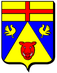
Blazon : Under a golden shield head with a continuous red common cross in blue with two golden facing golden doves , which shares a golden tip with a red facing (en face) boar head with silver eyes and tusks.
history
In 1305, the ban of Adompt appears for the first time in a document , which included Adompt, Gelvécourt and Bégnécourt. Adompt was part of the Bailiwick in Darney . The parish church in Adompt dates from the 12th century. It is still responsible for the surrounding communities of Les Ableuvenettes, Begnécourt and Légéville-et-Bonfays, which do not have their own churches. Gelvécourt belonged to the margraviate of Ville-sur-Illon from 1703 until the French Revolution .
Population development
| year | 1962 | 1968 | 1975 | 1982 | 1990 | 1999 | 2007 | 2017 | |
| Residents | 99 | 105 | 86 | 77 | 84 | 88 | 87 | 110 | |
| Sources: Cassini and INSEE | |||||||||
Attractions
- Saint-Martin-d'Adompt church, Monument historique with a nave from the 12th century and an organ by Henri Didier from 1893
Economy and Infrastructure
There are five farms in the municipality (grain cultivation, dairy farming, cattle breeding). Gelvécourt-et-Adompt is one of the few originally looking farming villages in the Vosges department.
The D 4 road runs through the municipality from Mirecourt to Bains-les-Bains . Immediately north of Gelvécourt-et-Adompt runs the partly two-lane expressway from Épinal to Vittel / Contrexéville .
supporting documents
- ↑ toponym on cassini.ehess.fr
- ↑ Description of the coat of arms on genealogie-lorraine.fr (French)
- ↑ vosges-archives.com, PDF file, French ( Memento of the original dated December 31, 2016 in the Internet Archive ) Info: The archive link was inserted automatically and has not yet been checked. Please check the original and archive link according to the instructions and then remove this notice.
- ↑ Gelvécourt-et-Adompt on cassini.ehess.fr
- ↑ Gelvécourt-et-Adompt on insee.fr
- ↑ Farms on annuaire-mairie.fr (French)

