
Puzieux (Vosges)
| Puzieux | ||
|---|---|---|

|
|
|
| region | Grand Est | |
| Department | Vosges | |
| Arrondissement | Epinal | |
| Canton | Mirecourt | |
| Community association | Mirecourt Dompaire | |
| Coordinates | 48 ° 20 ' N , 6 ° 6' E | |
| height | 268-345 m | |
| surface | 5.42 km 2 | |
| Residents | 148 (January 1, 2017) | |
| Population density | 27 inhabitants / km 2 | |
| Post Code | 88500 | |
| INSEE code | 88364 | |
 Location of Puzieux in the Vosges department |
||

Puzieux is a French commune with 148 inhabitants (as of January 1, 2017) in the Vosges department of the Grand Est region (until 2015 Lorraine ). It belongs to the Arrondissement Épinal and the Canton of Mirecourt .
geography
Puzieux is 40 kilometers south of Nancy at an altitude between 268 and 345 m above sea level. The municipality covers 5.42 km².
Neighboring municipalities of Puzieux are Frenelle-la-Grande in the north, Ambacourt in the north-east, Poussay in the east and south-east, Ramecourt in the south, Domvallier in the south-west, Juvaincourt in the west and Frenelle-la-Petite in the north-west.

Saint-Rémy church

town hall
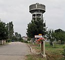
Former water tower


Population development
| year | 1962 | 1968 | 1975 | 1982 | 1990 | 1999 | 2007 | 2013 |
|---|---|---|---|---|---|---|---|---|
| Residents | 149 | 145 | 125 | 154 | 143 | 134 | 157 | 157 |
Attractions
- Chapel of Sainte-Menne


