
Saint-Pierremont (Vosges)
| Saint-Pierremont | ||
|---|---|---|
|
||
| region | Grand Est | |
| Department | Vosges | |
| Arrondissement | Epinal | |
| Canton | Raon-l'Étape | |
| Community association | Region of Rambervillers | |
| Coordinates | 48 ° 26 ' N , 6 ° 35' E | |
| height | 249-340 m | |
| surface | 5.51 km 2 | |
| Residents | 153 (January 1, 2017) | |
| Population density | 28 inhabitants / km 2 | |
| Post Code | 88700 | |
| INSEE code | 88432 | |
 Town hall and school building |
||

Saint-Pierremont is a French commune with 153 inhabitants (as of January 1, 2017) in the Vosges department in the Grand Est region (until 2015 Lorraine ); it belongs to the Arrondissement of Épinal and the canton of Raon-l'Étape .
geography

The municipality is located in the north of the Vosges department near the confluence of the Belvitte and Mortagne . The western municipal boundary also forms the border with the Meurthe-et-Moselle department .
The national road connections Bayon - Baccarat and Lunéville - Rambervillers intersect in Saint-Pierremont .
Population development
| year | 1962 | 1968 | 1975 | 1982 | 1990 | 1999 | 2007 | 2016 |
| Residents | 147 | 160 | 147 | 155 | 167 | 162 | 158 | 157 |
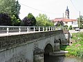
View to Saint-Pierremont over the Belvitte bridge

Saint-Pierre church

former lavoir in front of the church


Web links
Commons : Saint-Pierremont - Collection of images, videos and audio files