Racécourt
| Racécourt | ||
|---|---|---|

|
|
|
| region | Grand Est | |
| Department | Vosges | |
| Arrondissement | Epinal | |
| Canton | Darney | |
| Community association | Mirecourt Dompaire | |
| Coordinates | 48 ° 15 ′ N , 6 ° 11 ′ E | |
| height | 275-366 m | |
| surface | 7.23 km 2 | |
| Residents | 171 (January 1, 2017) | |
| Population density | 24 inhabitants / km 2 | |
| Post Code | 88270 | |
| INSEE code | 88365 | |
 Mairie Racécourt |
||
Racécourt is a French commune in the Vosges department in the Grand Est region (until 2015 Lorraine ). It belongs to the Arrondissement Épinal and the municipal association Mirecourt Dompaire, founded in 2017 .
geography
The municipality of Racécourt, with 171 inhabitants (January 1, 2017), is located about 22 kilometers northwest of Épinal , on the right bank of the Madon tributary Gitte . At the mouth of the tributary Robert, south of Racécourt, the Gittetal is almost a kilometer wide. To the north, the terrain rises by 60 meters.
The neighboring municipalities of Racécourt are Ahéville in the north, Bazegney in the east, Bouzemont in the southeast, Dompaire in the south and Velotte-et-Tatignécourt in the west.
history
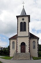
The place name appeared for the first time in 1365 in a document as Raceycourt , when the place still belonged to Velotte-et-Tatignécourt . The parish of Racécourt was initially a branch of Jorxey in the diocese of Toul . The Remiremont chapter received two thirds of the tithe, and the monastery in Chaumousey also received part . Racécourt was worldly dependent on the Bailiwick in Darney . The village church of St. Laurentius was built in 1856. The town hall and (boys) school building dates from 1835. The girls' school was built in 1869.
Population development
| year | 1962 | 1968 | 1975 | 1982 | 1990 | 1999 | 2007 | 2017 | |
| Residents | 151 | 148 | 135 | 120 | 156 | 151 | 147 | 171 | |
| Sources: Cassini and INSEE | |||||||||
Attractions
- 19th century church of St. Laurentius with statues of the Holy Virgin, St. Mauritius and St. Charles Borromeo ; the bell dates from 1772.
Economy and Infrastructure
There are three farms in the municipality (dairy farming, cattle breeding).
The D 266 trunk road leads through Racécourt from Dompaire to Mirecourt , a little further to the south-west the parallel D 166 from Épinal via Mirecourt to Neufchâteau . In the nearby municipality of Hymont, there is a connection to the railway line from Nancy via Mirecourt and Vittel to Merrey , which is operated by TER Lorraine .
supporting documents
- ↑ Racécourt on vosges-archives.com ( Memento of the original from March 4, 2016 in the Internet Archive ) Info: The archive link was inserted automatically and has not yet been checked. Please check the original and archive link according to the instructions and then remove this notice. (PDF file, French, accessed on September 16, 2015), no longer available since 2016
- ↑ Racécourt on cassini.ehess.fr
- ↑ Racécourt on insee.fr
- ↑ Farms on annuaire-mairie.fr (French)


