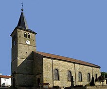
Uriménil
| Uriménil | ||
|---|---|---|
|
|
||
| region | Grand Est | |
| Department | Vosges | |
| Arrondissement | Epinal | |
| Canton | Le Val-d'Ajol | |
| Community association | Epinal | |
| Coordinates | 48 ° 6 ′ N , 6 ° 24 ′ E | |
| height | 338-465 m | |
| surface | 15.62 km 2 | |
| Residents | 1,355 (January 1, 2017) | |
| Population density | 87 inhabitants / km 2 | |
| Post Code | 88220 | |
| INSEE code | 88481 | |
 Mairie Uriménil |
||
Uriménil is a French commune with 1,355 inhabitants (as of January 1, 2017) in the Vosges department in the Grand Est region . It belongs to the Arrondissement Épinal and the municipal association Épinal .
geography
The municipality of Uriménil is about ten kilometers south of Épinal , near the source of the Côney . The European main watershed runs directly to the north and east of the municipality .
The districts of Chapuy-Chantré, Puits-des-Fées and Safframénil belong to Uriménil .
Neighboring municipalities of Uriménil are: Renauvoid and Épinal in the north, Dounoux in the east, Hadol in the south and Uzemain in the west.
history
Uriménil was first mentioned in a document in 1295 as Heurimesnil . In 1801 there was still the spelling Vrimenil .
Population development
| 1962 | 1968 | 1975 | 1982 | 1990 | 1999 | 2007 | 2017 | ||
| 1029 | 1090 | 1320 | 1538 | 1502 | 1397 | 1353 | 1355 | ||
| Sources: Cassini and INSEE | |||||||||

Economy and Infrastructure
In Uriménil, BIHR SA, a global packaging manufacturer that was founded in 1898, works. Twelve farms are located in the municipality (cereal and berry cultivation, dairy farming, cattle breeding).
The D44 road, which runs through the village, connects Uriménil with the neighboring communities of Uzemain and Dounoux . The capital of the department, Épinal, is ten kilometers from Uriménil. The nearest train station is in Dounoux on the Nancy - Belfort line .
supporting documents
- ↑ toponym on cassini.ehess.fr
- ↑ Uriménil on cassini.ehess.fr
- ↑ Uriménil on insee.fr
- ↑ Farms on annuaire-mairie.fr (French)

