Brantigny
| Brantigny | ||
|---|---|---|

|
|
|
| region | Grand Est | |
| Department | Vosges | |
| Arrondissement | Epinal | |
| Canton | Charms | |
| Community association | Epinal | |
| Coordinates | 48 ° 20 ' N , 6 ° 16' E | |
| height | 279-402 m | |
| surface | 3.01 km 2 | |
| Residents | 211 (January 1, 2017) | |
| Population density | 70 inhabitants / km 2 | |
| Post Code | 88130 | |
| INSEE code | 88073 | |
Brantigny is a French commune with 211 inhabitants (January 1, 2017) in the Vosges department in the Grand Est region ( Lorraine until 2015 ). It belongs to the Arrondissement Épinal and the municipal association Épinal .
geography
The municipality of Brantigny is four kilometers south of the small town of Charmes and about 25 kilometers northwest of Épinal in the hill country between the Moselle and Madon .
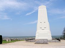
The municipality covers 3.01 km² and includes a section of the Madon tributary Colon and the hill country rising to the southwest and northeast of the Colon. The village of Brantigny lies on a terrace above the left bank of the Colon. Opposite the Colmé tributary coming from the east flows into the Colon. In the north, the municipality extends far and reaches up to a few meters from the Monument de Lorraine , a 13-meter-high stele visible from afar on the 384-meter-high Haut du Mont in memory of the battle of the Trouée de Charmes from 24th to 26th August 1914 at the beginning of the First World War. The hills in the west and north of the municipality are forested ( Le Bois Boha, Bois du Haut ), in the extreme southwest is 402 m above sea level. M. the highest point in the municipality. The largest part of the municipality consists of arable and pasture areas; orchards and an old vineyard lie immediately southwest of the village.
Neighboring communities of Brantigny are Charmes in the north, Ubexy in the east and south and Rugney in the west.
history
The name of the village appeared for the first time in 1163 as Brantinis in a document. At that time, the area was already part of the Duchy of Lorraine and dependent on the Moyenmoutier Abbey . Brantigny belonged to the Bailliage Charmes . Like those of the neighboring towns of Évaux-et-Ménil and Varmonzey, the residents were parish in Dommartin , a current district of Ubexy .
Population development
Brantigny is one of the smaller communities in the Vosges department. After the number of inhabitants was always over 200 in the 19th century, the population continued to decline and fell below the 100-inhabitant mark in 1875. Since then, slow growth has been observed again.
| year | 1962 | 1968 | 1975 | 1982 | 1990 | 1999 | 2006 | 2017 | |
| Residents | 121 | 127 | 95 | 162 | 151 | 149 | 175 | 211 | |
| Sources: Cassini and INSEE | |||||||||
Attractions
- Church of the Assumption ( Église de l'Assomption-de-Notre-Dame )
- Lavoir
- Fountain

Lavoir Brantigny
|
Economy and Infrastructure
Agriculture still plays an important role in Brantigny. There is also a forestry company in Brantigny. Some residents commute to the nearby town of Charmes or to the industrial areas in the Moselle valley.
Brantigny is on the main road from Charmes to Dompaire . There are other road connections to Varmonzey and Vincey . A connection to the two-lane national road 57 from Nancy to Épinal is four kilometers north of Brantigny. The stop in Vincey, six kilometers from Brantigny, is on the Nancy-Épinal- Remiremont railway line following the Moselle valley and operated by the TER Lorraine company.
supporting documents
- ↑ Brantigny on vosges-archives.com ( Memento of October 17, 2013 in the Internet Archive ) (French, PDF file; 103 kB)
- ↑ Brantigny on cassini.ehess.fr
- ↑ Brantigny on insee.fr
- ↑ Forestry enterprise on annuaire-mairie.fr (French)


