Domèvre-sur-Durbion
| Domèvre-sur-Durbion | ||
|---|---|---|
|
|
||
| region | Grand Est | |
| Department | Vosges | |
| Arrondissement | Epinal | |
| Canton | Bruyères | |
| Community association | Epinal | |
| Coordinates | 48 ° 17 ′ N , 6 ° 28 ′ E | |
| height | 299-365 m | |
| surface | 12.51 km 2 | |
| Residents | 267 (January 1, 2017) | |
| Population density | 21 inhabitants / km 2 | |
| Post Code | 88150 | |
| INSEE code | 88143 | |
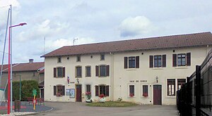
 Mairie Domèvre-sur-Durbion |
||
Domèvre-sur-Durbion is a French commune in the Vosges department in the region of Grand Est (2015 Lorraine ). It belongs to the Arrondissement Épinal and, since 2012, has been part of the Communauté d'agglomération d'Épinal .
geography
The municipality of Domèvre-sur-Durbion with 267 inhabitants (January 1, 2017) is located 13 kilometers north of the city center of Épinal , the capital ( chef-lieu ) of the Vosges department.
The 12.51 square kilometer municipal area includes a section of the valley of the Moselle tributary Durbion . The ground relief rises gently to the north and east; the plateau reaches 365 m above sea level on the eastern municipal boundary. The forest parts of the municipality in the north ( Bois des Évreux ) and east ( Bois des Épinettes, Bois Saint-Pierre ) belong to a large contiguous forest that extends twelve kilometers northeast to Rambervillers .
Neighboring municipalities of Domèvre-sur-Durbion are Hadigny-les-Verrières in the north, Badménil-aux-Bois in the north-east, Bayecourt in the south-east, Girmont in the south-west, Pallegney in the west and Zincourt in the north-west.
history
Until 1711 Domèvre was still part of the Bayecourt ban and dependent on the Remiremont chapter .
Population development
| year | 1962 | 1968 | 1975 | 1982 | 1990 | 1999 | 2006 | 2016 | |
| Residents | 251 | 281 | 254 | 255 | 280 | 300 | 265 | 275 | |
| Sources: Cassini and INSEE | |||||||||
Attractions
- Church of St. Mauritius ( Église Saint-Maurice ), Monument historique
- Crossroads ( Croix de Carrefour ) on the road to Girmont, Monument historique
- Remains of a Renaissance castle from the 16th century (destroyed in World War I)
Economy and Infrastructure
Agriculture still plays a role in Domèvre. Eight farms are located in the municipality (grain cultivation, dairy farming, cattle breeding). In addition to those employed in agricultural, small craft and service businesses, the commuters to the nearby urban area around Épinal and Thaon-les-Vosges are the largest group of workers in Domèvre.
Transport links
Départementsstraße 10 leads through Domèvre from Châtel-sur-Moselle to Girecourt-sur-Durbion . In Capavenir-Vosges , six kilometers away, there is a connection to the motorway-like RN 57 from Épinal to Nancy and to the TER Lorraine railway network ( Blainville-Damelevières – Lure line ).
supporting documents
- ↑ vincey-epinal-genealogie.com (French)
- ↑ Domèvre-sur-Durbion on cassini.ehess.fr
- ↑ Domèvre-sur-Durbion on insee.fr
- ^ Church of St. Mauritius in the Base Mérimée of the French Ministry of Culture (French)
- ↑ Crossroads in the Base Mérimée of the French Ministry of Culture (French)
- ↑ Pictures of the remains of the former castle
- ↑ Farms in annuaire-mairie-fr (French)


