Durbion
| Durbion | ||
|
Hydrography in the headwaters of the Durbion |
||
| Data | ||
| Water code | FR : A45-0200 | |
| location |
France
|
|
| River system | Rhine | |
| Drain over | Moselle → Rhine → North Sea | |
| source | in the municipality of Méménil, 48 ° 11 ′ 30 ″ N , 6 ° 37 ′ 29 ″ E |
|
| Source height | approx. 490 m | |
| muzzle | in the municipality of Châtel-sur-Moselle in the Moselle Coordinates: 48 ° 18 ′ 26 ″ N , 6 ° 24 ′ 12 ″ E 48 ° 18 ′ 26 ″ N , 6 ° 24 ′ 12 ″ E |
|
| Mouth height | approx. 285 m | |
| Height difference | approx. 205 m | |
| Bottom slope | approx. 5.9 ‰ | |
| length | 35 km | |
| Catchment area | 144.9 km² | |
| Drain at the mouth |
MQ |
1.95 m³ / s |
|
The river in Vaxoncourt, just before it flows into the Moselle |
||
The Durbion is a river in France that runs in the Vosges department in the Grand Est region .
geography
course

The upper Durbion in Girecourt
The Durbion rises at an altitude of about 490 m in the municipality of Méménil .
It drains initially in a northerly direction, then pivots to the northwest and finally flows by 35 kilometers at a height of about 285 m in the municipality of Chatel-sur-Moselle as right tributary in the Mosel .
The course of the Durbion ends about 205 meters below its source, so it has an average bed gradient of about 5.9 ‰.
Tributaries
- Petit Durbion ( right )
- Fontenay ( left ), 2.4 miles
- Abîme ( left ), 4.5 km
- Goule ( right ), 1.5 km
- Annol ( left ), 2.0 km
- Bouxy ( left ), 1.8 miles
- Onzaines ( right ), 6.8 miles
- Étangs ( left ), 4.6 km
Places on the river
- Viménil
- Gugnécourt
- Girecourt-sur-Durbion
- Sercoeur
- Villoncourt
- Bayecourt
- Domèvre-sur-Durbion
- Vaxoncourt
Attractions
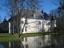
- Girecourt Castle from the 16th century ( Monument historique )
Web links
- Débits caractéristiques du Durbion (PDF; 14 kB; French)


