
Dounoux
| Dounoux | ||
|---|---|---|

|
|
|
| region | Grand Est | |
| Department | Vosges | |
| Arrondissement | Epinal | |
| Canton | Le Val-d'Ajol | |
| Community association | Epinal | |
| Coordinates | 48 ° 6 ′ N , 6 ° 27 ′ E | |
| height | 360-520 m | |
| surface | 9.23 km 2 | |
| Residents | 855 (January 1, 2017) | |
| Population density | 93 inhabitants / km 2 | |
| Post Code | 88220 | |
| INSEE code | 88157 | |
 Mairie Dounoux |
||

Dounoux (1793 still with the spelling Donnoux ) is a French commune with 855 inhabitants (as of January 1, 2017) in the Vosges department in the Grand Est region . It belongs to the Arrondissement Épinal and, since January 1, 2012, has been part of the newly established municipal association Agglomération d'Épinal .
geography

The municipality of Dounoux lies on average 416 meters above sea level on the high plateau of the Vôge , which forms a section of the watershed between the catchment areas of Saône / Rhône and Moselle / Rhine .
The 9.23 km² large, elongated municipality area consists of 31% forest, which is mainly to be found in the north and south. In the north lies the source of the Côney , a tributary of the Saône , while the Ruisseau de Rainjumenil, a small, direct tributary of the Moselle, rises near the train station .
Neighboring municipalities of Dounoux are Épinal and Dinozé in the north, Arches in the northeast, Hadol in the east and south and Uriménil in the west.
history
The first mention of the village goes back to a document from 1390. It was about a share of the tithe Jacob d'Ancelle received from the villages of Urimenil and Dounnoux .
In the time of the Ancien Régime, the area of today's parish was under the provost's office in Arches and the abbesses of the Chapitre de Remiremont .
The following agricultural products of the farmers in Dounoux were recorded for the year 1789: rye, barley, buckwheat, oats, flax, hemp, potatoes and hay.
Due to the open, high location of Dounoux, the community was hit particularly hard by Hurricane Lothar in December 1999 .
Population development
| year | 1962 | 1968 | 1975 | 1982 | 1990 | 1999 | 2007 | 2017 | |
| Residents | 353 | 372 | 457 | 711 | 807 | 788 | 790 | 855 | |
| Sources: Cassini and INSEE | |||||||||
Attractions
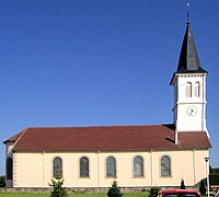
- Church of St. Medardus ( Église Saint-Médard ), built in 1843
- Remains of the Fort du Bambois, built in 1880, in a forest north of Dounoux
- Church of St. Medardus in Dounoux


Economy and Infrastructure
In addition to a few small craft shops, a factory (Prodefica SARL) has set up shop on Rue du Tissage that produces soaps and detergents. There are 14 farms in the municipality (dairy farming, poultry, cattle, sheep and goat breeding). Some workers commute to the surrounding larger towns, mainly to the nearby town of Épinal .
The national road 434 ( Épinal - Vesoul ) runs north-south through the municipality of Dounoux. Other roads lead to the neighboring communities of Hadol and Uriménil . Dounoux station is on the Nancy - Belfort line , operated by the TER Lorraine company.
Web links
- Fort du Bambois (French)
- Population statistics
Individual evidence
- ↑ toponym on cassini.ehess.fr
- ↑ Dounoux on cassini.ehess.fr
- ↑ Dounoux on insee.fr
- ↑ Farms on annuaire-mairie.fr (French)