
Uzemain
| Uzemain | ||
|---|---|---|
|
||
| region | Grand Est | |
| Department | Vosges | |
| Arrondissement | Epinal | |
| Canton | Le Val-d'Ajol | |
| Community association | Epinal | |
| Coordinates | 48 ° 5 ' N , 6 ° 21' E | |
| height | 305-467 m | |
| surface | 27.30 km 2 | |
| Residents | 1,055 (January 1, 2017) | |
| Population density | 39 inhabitants / km 2 | |
| Post Code | 88220 | |
| INSEE code | 88484 | |
| Website | http://www.uzemain.fr/ | |
 Mairie Uzemain |
||

Uzemain is a French commune with 1,055 inhabitants (as of January 1, 2017) in the Vosges department in the Grand Est region . It belongs to the Arrondissement Épinal and the municipal association Épinal .
geography

The municipality of Uzemains lies on average 320 meters above sea level and extends from the valley of the upper Côney to the high plateau of the Vôge , which forms a section of the watershed between the catchment areas of the Saône and the Moselle .
The 27.3 km² large municipal area includes the main town of Uzemain, the districts of La Xatte, Le Roulon, Les Forges d'Uzemain, Méloménil, Naymont and Thièlouze . The Canal des Vosges runs through the west of the municipal area and leaves the Côney Valley in Les Forges d'Uzemain, continuing to climb northwards to the apex position . Uzemain is located in an agriculturally used area made up of arable and meadow land, with forests predominant in the northeast.
Uzemain's neighboring municipalities are Girancourt in the north, Renauvoid in the northeast, Uriménil in the east, Hadol in the southeast, Xertigny in the south, Charmois-l'Orgueilleux in the west and Dommartin-aux-Bois in the northwest.
history
In 1790 the villages of Uzemain-les Forges and Uzemain-la Rue were formed from existing small hamlets. From the merger of the two villages, today's municipality of Uzemain was created in 1839 by royal order.
In the 18th century, Uzemain was one of the locations of the iron industry in the Vôge region due to its wealth of firewood and the nearby Burgundian ore , and Bains-les-Bains , 20 kilometers away, even housed the largest iron factory in Lorraine during this time.
Population development
| 1962 | 1968 | 1975 | 1982 | 1990 | 1999 | 2006 | 2017 | ||
| 948 | 849 | 842 | 896 | 1008 | 1043 | 1096 | 1055 | ||
| Sources: Cassini and INSEE | |||||||||
Attractions
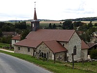
- Sainte-Madelaine church in neo-Gothic style, built in 1866
- Notre-Dame de l'Annonciation chapel with tower from 1501 in the Thièlouze district

Uzemain's landmark, visible from afar: the Sainte-Madeleine church, built in 1866
Notre-Dame-du-Chardonneret chapel in the Thiélouze district

Water reservoir on the Canal des Vosges at Les Forges-d'Uzemain


Economy and Infrastructure
There are 22 farms in the municipality of Uzemain (cereal and vegetable growing, dairy farming, horse and cattle breeding). There is a long tradition of making spirits in the area, which the building of an old distillery reminds us of today. In addition to a few small craft and catering businesses, there is a factory in Rue du Côney that makes decorative adhesive tapes . Some workers commute to the surrounding larger towns.
In 1999 a new school for 140 students was built in the community.
The highways D 44 and D 51 running through the village connect Uzemain with Épinal and the surrounding communities. The nearest train station is in the small town of Xertigny, seven kilometers away, on the Blainville-Damelevières-Lure railway line .