
Villers (Vosges)
| Villers | ||
|---|---|---|

|
|
|
| region | Grand Est | |
| Department | Vosges | |
| Arrondissement | Epinal | |
| Canton | Mirecourt | |
| Community association | Mirecourt Dompaire | |
| Coordinates | 48 ° 18 ' N , 6 ° 10' E | |
| height | 280-386 m | |
| surface | 4.97 km 2 | |
| Residents | 209 (January 1, 2017) | |
| Population density | 42 inhabitants / km 2 | |
| Post Code | 88500 | |
| INSEE code | 88507 | |
 Location of the municipality of Villers in the Vosges department |
||

Villers is a French commune in the department of Vosges in the region Grand Est . It belongs to the Arrondissement Épinal and the municipal association Mirecourt Dompaire, founded in 2017 .
geography
The municipality of Villers, with 209 inhabitants (January 1, 2017), is located 32 kilometers northwest of Épinal in the hill country between the Moselle and Madon .
81 hectares of the community area are forested.
Neighboring communities of Villers are Mazirot in the north, Avillers in the northeast, Vroville in the south and Mirecourt in the west.
history
The village of Villers has been known in written documents since at least 1558. During the Ancien Régime , Villers belonged to the Bailliage Mirecourt , and the parish was under the Remiremont chapter .
A cholera epidemic has survived from 1854 that claimed 20 victims.
The Mairie and school building dates from 1848, the church was built in 1845.
Population development
| year | 1962 | 1968 | 1975 | 1982 | 1990 | 1999 | 2007 | 2017 | |
| Residents | 124 | 125 | 118 | 186 | 231 | 214 | 219 | 209 | |
| Sources: Cassini and INSEE | |||||||||
Attractions
- Sainte-Lot Church
- monumental wayside cross next to the 17th century church, classified as a monument historique
- Rabiémont Chapel
- Fallen memorial


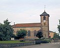
East side of the church

Northwest side of the church

Monumental cross

Rabiémont Chapel


Economy and Infrastructure
There are four farms in the municipality (dairy farming, cattle, sheep and goat breeding).
The D 32 trunk road from Charmes to Rambervillers runs through the municipality of Essegney . In the nearby town of Charmes there is a connection to the motorway-like RN 57 from Nancy to Épinal . Charmes station, one and a half kilometers from Essegney, is on the Blainville-Damelevières-Lure railway line .
supporting documents
- ↑ http: // Villers on vosges-archives.com. (pdf; 37 kB) (No longer available online.) Archived from the original on March 4, 2016 ; Retrieved November 1, 2010 (French). Info: The archive link was inserted automatically and has not yet been checked. Please check the original and archive link according to the instructions and then remove this notice.
- ↑ Villers on cassini.ehess.fr
- ↑ Villers on insee.fr
- ↑ http: // entry on culture.gouv.fr. Retrieved November 1, 2010 (French).
- ↑ Farms on annuaire-mairie.fr (French)