
Arches (Vosges)
| Arches | ||
|---|---|---|

|
|
|
| region | Grand Est | |
| Department | Vosges | |
| Arrondissement | Epinal | |
| Canton | Epinal-1 | |
| Community association | Epinal | |
| Coordinates | 48 ° 7 ' N , 6 ° 32' E | |
| height | 335-521 m | |
| surface | 17.50 km 2 | |
| Residents | 1,638 (January 1, 2017) | |
| Population density | 94 inhabitants / km 2 | |
| Post Code | 88380 | |
| INSEE code | 88011 | |
 Mairie Arches |
||

Arches is a French commune with 1638 inhabitants (as of January 1, 2017) in the Vosges department in the Grand Est region (until 2015 Lorraine ). It belongs to the Arrondissement Épinal and the municipal association Épinal .
geography

Arches is located on the upper Moselle , about ten kilometers southeast of Épinal -
The municipality of Arches extends from the left bank of the upper Moselle to the high plateau of the Vôge . The core town of Arches is located in the area of the mouths of the small rivers Ruisseau des Nauves and Niche in the Moselle, here the left Moselle valley is significantly wider than in sections further south or north.
The landscape is characterized by fields and orchards at lower elevations, while in the higher north of the municipality, the Bois d'Arches is a large, contiguous forest area. The south of the community is also covered with forest, so that the proportion of forest in the entire community area is almost two thirds.
The 17.5 km² large municipal area includes the main town Arches, the districts Aneuménil and Le Saucey and the hamlets of La Garde de Dieu, Le Roxard and Laménil .
Neighboring communities of Arches are Épinal in the north, Archettes in the northeast, Pouxeux in the east, Raon-aux-Bois in the south, Hadol in the southwest and west and Dounoux and Dinozé in the northwest.
history
Arches can be translated as arches / gates . The arches can be traced back to a bridge over the Moselle from Roman times. The four-arched bridge is also the symbol of the Arches coat of arms.
In 1080 Duke Dietrich II of Lorraine had a castle built in Arches. The street names Rue du Château and Chemin de Château are reminiscent of the remains of this fortification . The provost's office of the castle existed until 1754.
Arches was internationally known for its pure and strong paper, which has been produced here since 1492. In 1778 Beaumarchais ordered 70 tons of paper from Arches for the planned 70 volumes of Voltaire's complete works , but this failed.

Population development
| year | 1962 | 1968 | 1975 | 1982 | 1990 | 1999 | 2006 | 2017 | |
| Residents | 1572 | 1588 | 1523 | 1718 | 1737 | 1679 | 1722 | 1638 | |
| Sources: Cassini and INSEE | |||||||||
Attractions
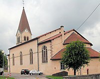
- Saint-Maurice church from the 19th century
- Paper mill with a visitor service
- Remnants of the city wall
- Fort d'Arches
- Saint-Maurice church in Arches


Economy and Infrastructure
In addition to the traditional wood and paper industry (sawmill, paper mill) there are also smaller agricultural and handicraft businesses in Arches. There are six farms in the municipality (dairy, horse and cattle breeding). Some workers commute to the nearby town of Épinal .
Arches is the school location. On April 29, 2009 the foundation stone for a new town hall and school building ( Mairie-école ) was laid.

The two-lane N 57 and D 157 (both from Épinal to Remiremont ) run through Arches parallel to the Moselle . Arches station is on the Nancy- Épinal-Remiremont railway line, which also follows the Moselle valley . The Épinal- Saint-Dié-des-Vosges - Saales - Strasbourg line branches off from this line in Arches . Both routes are operated by TER Lorraine .
literature
- Michel Vernus: La fabuleuse histoire du papier , edition Cabedita, 2004.