
Dombasle-en-Xaintois
| Dombasle-en-Xaintois | ||
|---|---|---|

|
|
|
| region | Grand Est | |
| Department | Vosges | |
| Arrondissement | Epinal | |
| Canton | Mirecourt | |
| Community association | Mirecourt Dompaire | |
| Coordinates | 48 ° 18 ' N , 6 ° 0' E | |
| height | 328-389 m | |
| surface | 4.72 km 2 | |
| Residents | 124 (January 1, 2017) | |
| Population density | 26 inhabitants / km 2 | |
| Post Code | 88500 | |
| INSEE code | 88139 | |
 Mairie Dombasle-en-Xaintois |
||

Dombasle-en-Xaintois is a French commune with 124 inhabitants (as of January 1, 2017) in the arrondissement Épinal des Départementes Vosges . It is part of the Mirecourt Dompaire municipal association .
geography

The street village of Dombasle-en-Xaintois, halfway between Épinal and Neufchâteau, is located in the south of the Xaintois , a plateau that separates the catchment areas of the rivers Vair (a tributary of the Meuse ) and Madon (tributary of the Moselle ).
Neighboring communities of Dombasle-en-Xaintois are Totainville and Oëlleville in the north, Rouvres-en-Xaintois in the east and south-east and Ménil-en-Xaintois in the west.
history
The place name can be traced back to Saint Basolus von Verzy (French Basle de Verzy ), who evangelized large parts of Lorraine.
The area around Dombasle belonged to the domain of the Counts of Toul , from the 13th century to the Duchy of Lorraine and finally to France from 1766 according to the Peace of Vienna .
Population development
| year | 1962 | 1968 | 1975 | 1982 | 1990 | 1999 | 2007 | 2017 | |
| Residents | 135 | 146 | 141 | 148 | 139 | 119 | 122 | 124 | |
| Sources: Cassini and INSEE | |||||||||
Attractions
- St. Basolus Church from the 19th century
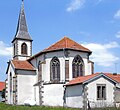
St. Basolus Church


Economy and Infrastructure
Agriculture and forestry continue to play an important role in Dombasle and the surrounding area. There are two farms in the community (vegetable growing, horse breeding).
The houses in the typical street village, located around 50 kilometers south of Nancy , are grouped along the D 166 highway, which leads from Épinal via Mirecourt to Neufchâteau and crosses the A31 autoroute ( Beaune - Metz - Luxembourg ) ten kilometers west of Dombasle .
supporting documents
- ↑ Dombasle-en-Xaintois on cassini.ehess.fr
- ↑ Dombasle-en-Xaintois on insee.fr
- ↑ Farms on annuaire-mairie.fr (French)