
Saint-Benoît-la-Chipotte
| Saint-Benoît-la-Chipotte | ||
|---|---|---|
|
||
| region | Grand Est | |
| Department | Vosges | |
| Arrondissement | Epinal | |
| Canton | Raon-l'Étape | |
| Community association | Region of Rambervillers | |
| Coordinates | 48 ° 21 ' N , 6 ° 44' E | |
| height | 324-524 m | |
| surface | 20.77 km 2 | |
| Residents | 417 (January 1, 2017) | |
| Population density | 20 inhabitants / km 2 | |
| Post Code | 88700 | |
| INSEE code | 88412 | |
 Location of Saint-Benoît-la-Chipotte in the Vosges department |
||

Saint-Benoît-la-Chipotte is a French commune in the Vosges department in the region of Grand Est (2015 Lorraine ). It belongs to the Arrondissement Épinal and the canton Raon-l'Étape . It has 417 inhabitants (as of January 1, 2017).
Saint-Benoît-la-Chipotte is a mainly agricultural and forestry municipality on the first heights of the Vosges . It is located at an altitude of approx. 355 m, 7 km from Rambervillers and 14 km from Raon-l'Étape , below the Col de la Chipotte (456 m).
Population development
| 1962 | 1968 | 1975 | 1982 | 1990 | 1999 | 2006 | 2017 |
|---|---|---|---|---|---|---|---|
| 371 | 341 | 335 | 325 | 362 | 370 | 404 | 417 |
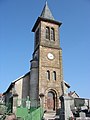
Saint-Benoît church

Entrance to the French war cemetery of the First World War


Web links
Commons : Saint-Benoît-la-Chipotte - Collection of images