Igney (Vosges)
| Igney | ||
|---|---|---|

|
|
|
| region | Grand Est | |
| Department | Vosges | |
| Arrondissement | Epinal | |
| Canton | Golbey | |
| Community association | Epinal | |
| Coordinates | 48 ° 16 ' N , 6 ° 24' E | |
| height | 286-373 m | |
| surface | 7.66 km 2 | |
| Residents | 1,168 (January 1, 2017) | |
| Population density | 152 inhabitants / km 2 | |
| Post Code | 88150 | |
| INSEE code | 88247 | |
 Mairie Igney |
||
Igney is a French commune with 1,168 inhabitants (as of January 1, 2017) in the Vosges department in the Grand Est region (until 2015 Lorraine ). It belongs to the Arrondissement Épinal and since 2012 the municipal association Agglomération d'Épinal .
geography
Igney is located on the upper Moselle , ten kilometers north of Épinal , the capital (chef-lieu) of the arrondissement of the same name.
The 7.66 km² community of Igney has an approx. 30 hectare pond area on the right side of a loop of the Moselle, the majority of which extends from the left bank of the Moselle to the wooded hills west of the town center, which tower over the riverbed of the Moselle by almost 80 meters . The Canal des Vosges runs parallel to the left of the Moselle ; two of its 93 locks are in the Igneys area.
The locations in the Moselle valley are used for agriculture or are characterized by residential and commercial areas. The proportion of forest in the municipality is around 40%.
Neighboring municipalities of Igney are Nomexy in the north, Vaxoncourt in the east, Capavenir Vosges in the south and southwest and Frizon in the west.
history
Remains of a Roman road towards Bois de la Héronnière , a wooded area west of Igney, indicate early settlement.
The existence of a parish is recorded for the 10th century, which drew the tithe to the Remiremont monastery . Igney belonged to the domain of the Mitry family, an old noble family from Lorraine, until the French Revolution.
In early 1814, a battle of the Wars of Liberation raged near Igney , which the French won against a Cossack army.
From the end of the 19th century, like in the entire upper Moselle valley, the textile industry with a weaving mill and a spinning mill found its way into Igney. The peak of the number of employees was reached in the 1960s with 600. With the closure of the Boussac company , unemployment rose in Igney and there was increased emigration. In the decades that followed, a new economic structure was gradually built up.
Population development
The effects of the decline of the textile industry could be read in the development of the population of Igney until the 1980s, since then it has been recovering.
| year | 1962 | 1968 | 1975 | 1982 | 1990 | 1999 | 2007 | 2017 | |
| Residents | 1308 | 1310 | 1307 | 1171 | 1075 | 1090 | 1112 | 1168 | |
| Sources: Cassini and INSEE | |||||||||
Attractions
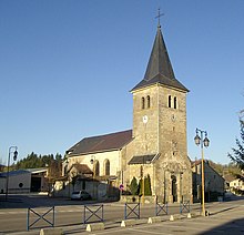
- Saint-Nicolas church, classified as a monument historique
Economy and Infrastructure
As in the other municipalities in the upper Moselle valley, agriculture and forestry play only a subordinate role today, with eight farms still based in Igney (dairy farming, cattle breeding). In the south of the municipality of Igney there is the 4 hectare industrial park (zone industrial) ZI de Fontenay . In addition to craft and trading companies, some national metal construction companies have settled here. They include SA Coanus , Portalys, and Joel Deloy .
In Nomexy, the D 41 (to Sanchey ) branches off from the D 157, which runs along the left bank of the Moselle. The two-lane national road 57 from Nancy to Épinal runs with a junction through the municipality of Igney. The Igney stop is on the Nancy-Épinal- Remiremont railway line that follows the Moselle valley and is operated by the TER Lorraine company.
supporting documents
- ↑ Igney on cassini.ehess.fr
- ↑ Igney on insee.fr
- ↑ Entry on culture.gouv.fr. Retrieved January 14, 2011 (French).
- ↑ Farms on annuaire-mairie.fr (French)
Web links
- History of Igney (French)
- Population statistics


