
Oëlleville
| Oëlleville | ||
|---|---|---|

|
|
|
| region | Grand Est | |
| Department | Vosges | |
| Arrondissement | Epinal | |
| Canton | Mirecourt | |
| Community association | Mirecourt Dompaire | |
| Coordinates | 48 ° 20 ' N , 6 ° 1' E | |
| height | 308-391 m | |
| surface | 10.08 km 2 | |
| Residents | 306 (January 1, 2017) | |
| Population density | 30 inhabitants / km 2 | |
| Post Code | 88500 | |
| INSEE code | 88334 | |
 Location of the municipality of Oëlleville in the Vosges department |
||

Oëlleville (1801 still with the spelling Oelleville ) is a French commune in the Vosges department in the Grand Est region . It belongs to the Arrondissement Épinal and the municipal association Mirecourt Dompaire, founded in 2017 .
geography
The municipality of Oëlleville in the Xaintois, with 306 inhabitants (January 1, 2017), is located in the north of the Vosges department, near the border with the Meurthe-et-Moselle department , ten kilometers northwest of the small town of Mirecourt . The Ruisseau d' Oëlleville rises in Oëlleville , a stream that flows into the Madon after ten kilometers . The Western community boundary extends along the Rhine - Maas - watershed .
Neighboring communities of Oëlleville are Chef-Haut in the north, Blémerey and Frenelle-la-Petite in the northeast, Juvaincourt in the east, Baudricourt in the southeast, Rouvres-en-Xaintois in the south, Dombasle-en-Xaintois in the southwest, Totainville in the west and Repel in the Northwest.
history
The origin of the village goes back to a Gallo-Roman place. 1147 appears in a document apud Ollei villam - a settlement near Ollei . The ban of Oëlleville was under the abbesses and the chapter in Remiremont alike. Before the French Revolution, Oëlleville belonged to the Bassompierre and Tilly families and was part of the Baillage Mirecourt .
Population development
| year | 1962 | 1968 | 1975 | 1982 | 1990 | 1999 | 2007 | 2017 | |
|---|---|---|---|---|---|---|---|---|---|
| Residents | 313 | 329 | 344 | 314 | 291 | 278 | 295 | 306 | |
| Sources: Cassini and INSEE | |||||||||
Attractions
- Church of Saint-Brice ( St. Brictius ) from the 15th / 16th centuries Century, including with an altarpiece of the Virgin, which as historique monument is classified
- Lavoir
- two wayside crosses and a large plague cross from 1856
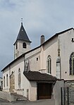
Saint-Brice church

town hall
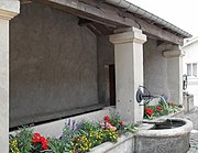
Lavoir
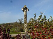
monumental plague cross


Economy and Infrastructure
Twelve farms are located in the municipality (grain cultivation, dairy farming, cattle breeding).
The D29 trunk road from Baudricourt to Aroffe runs through Oëlleville . Four kilometers south of the D 166 trunk road, which is partially expanded to two lanes, runs from Épinal to Neufchâteau .
supporting documents
- ↑ toponym on cassini.ehess.fr
- ↑ Oëlleville on vosges-archives.com/ ( Memento of the original from March 4, 2016 in the Internet Archive ) Info: The archive link was inserted automatically and has not yet been checked. Please check the original and archive link according to the instructions and then remove this notice. (French, PDF; 39 kB)
- ↑ Oëlleville on cassini.ehess.fr
- ↑ Oëlleville on insee.fr
- ↑ Farms on annuaire-mairie.fr (French)