Varmonzey
| Varmonzey | ||
|---|---|---|
|
|
||
| region | Grand Est | |
| Department | Vosges | |
| Arrondissement | Epinal | |
| Community association | Mirecourt Dompaire | |
| Coordinates | 48 ° 19 ′ N , 6 ° 17 ′ E | |
| height | 286-395 m | |
| surface | 2.57 km 2 | |
| Residents | 28 (January 1, 2017) | |
| Population density | 11 inhabitants / km 2 | |
| Post Code | 88450 | |
| INSEE code | 88493 | |
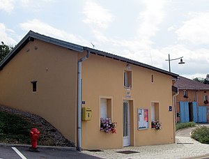
 Mairie Varmonzey |
||
Varmonzey is a French commune with 28 inhabitants (as of January 1, 2017) in the Vosges department . It belongs to the Arrondissement Épinal and the municipal association Mirecourt Dompaire, founded in 2017 . The residents call themselves Varmonzeyeilles .
geography
The small municipality of Varmonzey is located about 23 kilometers northwest of Épinal in the valley of the Colon River , which flows in a south-north direction through the 2.57 km² municipal area. The bank of the Colon is about 290 m above sea level; west of the bank the terrain gradually rises up to 360 m, on the eastern bank a steep step rises around 100 meters to a plateau, which is the highest point on the western flank of the Haut de Chalmont on the eastern border of the municipality at 395 m above sea level reached. The village of Varmonzey is located in a bay on the steep slope that opens to the west, and the associated hamlet of Le Faxal is located on the flat Westofer des Colon. The largest part of the community area consists of fields and pastures. There are smaller patches of forest on the steep slopes and as remains of alluvial forest on the rivers of Colon and Ruisseau de la Tarpe . In the south-west of the municipality there is the Bois d'Ascensement, a forest area of around 14 hectares. The field name Corvée de la Vigne west of the Colon is still a reminder of viticulture in earlier times . A few vines for personal consumption can be found east of the village of Varmonzey.
Varmonzey is surrounded by the neighboring communities of Ubexy in the north, Évaux-et-Ménil in the east, Gugney-aux-Aulx in the south and Rapey in the west.
history
Varmonzey first appeared in documents as Warmonzeyz in 1292 and was dependent on the neighboring village of Gugney-aux-Aulx , which belonged to the abbesses of Remiremont and the lords of Ubexy and Mazirot . Also ecclesiastically, the residents of Varmonzey belonged to the parishes in Gugney-aux-Aulx and Évaux-et-Ménil . A church was never built in Varmonzey.
Population development
In 1831 the highest number of inhabitants to date was registered at 104.
| year | 1962 | 1968 | 1975 | 1982 | 1990 | 1999 | 2007 | 2017 | |
| Residents | 21st | 20th | 18th | 23 | 25th | 25th | 24 | 28 | |
| Sources: Cassini and INSEE | |||||||||
Attractions
- Crossroads on the road to Évaus-et-Mébil
Economy and Infrastructure
There are three farms in the municipality (dairy farming, poultry farming).
Varmonzey is connected to its neighboring communities by back roads. In the municipality of Vincey , four kilometers away, there is a connection to the motorway-like RN 57 from Nancy to Épinal . The train station in Vincey is on the Blainville-Damelevières-Lure railway line .
supporting documents
- ↑ Varmonzey on vosges-archives.com , PDF file (French)
- ↑ Varmonzey on cassini.ehess.fr
- ↑ Varmonzey on insee.fr
- ↑ Farms on annuaire-mairie.fr (French)

