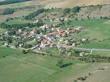
Ramecourt (Vosges)
| Ramecourt | ||
|---|---|---|

|
|
|
| region | Grand Est | |
| Department | Vosges | |
| Arrondissement | Epinal | |
| Canton | Mirecourt | |
| Community association | Mirecourt Dompaire | |
| Coordinates | 48 ° 19 ′ N , 6 ° 6 ′ E | |
| height | 274-345 m | |
| surface | 3.26 km 2 | |
| Residents | 189 (January 1, 2017) | |
| Population density | 58 inhabitants / km 2 | |
| Post Code | 88500 | |
| INSEE code | 88368 | |
 Ramecourt Town Hall ( Mairie ) |
||
Ramecourt is a French commune with 189 inhabitants (as of January 1, 2017) in the Vosges department in Grand Est . It belongs to the Arrondissement Épinal and the Canton of Mirecourt . The residents call themselves Ramecurtiens .
geography
The municipality of Ramecourt is located on the south-eastern edge of the Xaintois landscape , about 40 kilometers north-west of Épinal . The area around Ramecourt is characterized by hills and the wide floodplain of the Val d'Arol , a left tributary of the Madon . The north, left bank of the river Val d'Arol is accompanied by a steep, 50-meter-high step. On the plateau above this step, the highest point in the municipality is reached at 345 m. Apart from the smaller trees on the river banks, the community is very poor in forests.
Neighboring communities of Ramecourt are Puzieux in the north, Poussay in the northeast, Mirecourt in the southeast, Thiraucourt in the southwest and Domvallier in the west.
history
The name Ramecourt first appeared in a document from 1187. During the Ancien Régime , Ramecourt was part of the Mirecourt Bailiwick . Ecclesiastically, Ramecourt was always part of the parish in the neighboring parish of Domvallier . Ramecourt has no church to this day. There used to be a small oratory , of which no remains have survived today. The municipality's archive was lost between 1970 and 1996 - probably when moving from the old town hall and school building ( mairie-école ) to the new town hall.
Population development
| year | 1962 | 1968 | 1975 | 1982 | 1990 | 1999 | 2008 | 2013 |
| Residents | 198 | 185 | 186 | 161 | 159 | 175 | 168 | 170 |
Ramecourt reached its highest level since the census began in 1793 in 1846 with a population of 239.
Attractions
- two large hall crosses
Economy and Infrastructure
Agriculture still plays a role in Ramecourt (grain and feed cultivation). Some residents are commuters to the industrial parks at the nearby Épinal-Mirecourt Airport or to Gironcourt-sur-Vraine . South of Ramecourt is the complex of a psychiatric clinic ( Hôpital psychiatrique de Ravenel ). The partly two-lane expressway (D 166) from Épinal via Mirecourt to Neufchâteau leads through Ramecourt.
supporting documents
- ↑ Ramecourt on vosges-archives.com. (pdf file) (No longer available online.) Archived from the original on May 30, 2016 ; Retrieved May 30, 2016 (French). Info: The archive link was inserted automatically and has not yet been checked. Please check the original and archive link according to the instructions and then remove this notice.
Web links
- Population statistics since 1793 (French)

