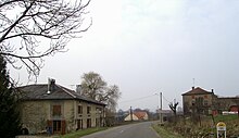
Les Ableuvenettes
| Les Ableuvenettes | ||
|---|---|---|
|
|
||
| region | Grand Est | |
| Department | Vosges | |
| Arrondissement | Epinal | |
| Canton | Darney | |
| Community association | Mirecourt Dompaire | |
| Coordinates | 48 ° 11 ' N , 6 ° 11' E | |
| height | 293-387 m | |
| surface | 4.49 km 2 | |
| Residents | 62 (January 1, 2017) | |
| Population density | 14 inhabitants / km 2 | |
| Post Code | 88270 | |
| INSEE code | 88001 | |
 Location of Les Ableuvenettes in the Vosges department |
||
Les Ableuvenettes is a French commune with 62 inhabitants (as of January 1, 2017) in the Vosges department in the Grand Est region (until 2015 Lorraine ). It belongs to the Arrondissement Épinal and the Canton of Darney .
geography
The municipality of Les Ableuvenettes is five kilometers south of Dompaire . The Illon flows through the village , a right tributary of the Madon , which separates Petite Ableuvenette (left) and Grande Ableuvenette (right of Illon) from each other.
Neighboring municipalities of Les Ableuvenettes are Dompaire in the northeast, Ville-sur-Illon in the southeast, Pierrefitte in the south, Légéville-et-Bonfays in the west and Gelvécourt-et-Adompt in the northwest.
history
During excavations, coins came to light that testify to a former visit by Romans . It was first mentioned in 1148 under the place name "Albuvisnei". The place was later called "Aublevenay".
Les Ableuvenettes does not have its own church; the church in the neighboring parish of Ville-sur-Illon is responsible for the residents .
Population development
| year | 1962 | 1968 | 1975 | 1982 | 1990 | 1999 | 2007 | 2014 |
| Residents | 71 | 92 | 82 | 85 | 70 | 69 | 62 | 79 |


