
Gruey-lès-Surance
| Gruey-lès-Surance | ||
|---|---|---|
|
||
| region | Grand Est | |
| Department | Vosges | |
| Arrondissement | Epinal | |
| Canton | Le Val-d'Ajol | |
| Community association | Epinal | |
| Coordinates | 48 ° 2 ' N , 6 ° 11' E | |
| height | 323-488 m | |
| surface | 27.10 km 2 | |
| Residents | 262 (January 1, 2017) | |
| Population density | 10 inhabitants / km 2 | |
| Post Code | 88240 | |
| INSEE code | 88221 | |
 Location of the commune of Gruey-lès-Surance in the Vosges department |
||

Gruey-lès-Surance is a French commune with 262 inhabitants (as of January 1, 2017) in the Vosges department in the Grand Est region . It belongs to the Arrondissement Épinal and the municipal association Épinal .
geography
Gruey-lès-Surance is located at an average altitude of 425 m above sea level, ten kilometers northwest of Bains-les-Bains and 22 kilometers southeast of Vittel in the extreme south of Lorraine on the border with the Bourgogne-Franche-Comté region .
The 27.1 km² large municipal area is located on the Vôge plateau between the upper Saône valley and the Côney valley . The Ruisseau d'Heuillon and Ruisseau du Houe streams rise on the high plateau and join together in Gruey-lès-Surance to form the Ruisseau de Gruey tributary to the Côney . In the north-west of the municipality is the source of the Ourche , the first notable tributary of the Saône, and in the south-west the Ruisseau des Cerisiers forms the border with the Franche-Comté region.
The plateau is used for agriculture, while the slopes in the south ( Bois de Montroche ) and west ( Forêt Domaniale de Darney ) of the municipality consist of forests. The Forêt Domaniale de Darney is one of the largest contiguous mixed forest areas in the Vosges department. In the south of the municipality, the terrain drops in one step by around 80 meters. To the north of the core town is the approximately 3 hectare dammed pond Étang des Cerisiers . Another pond in the southwest of the municipality bears this name.
The place Gruey-lès-Surance has two settlement axes: the north-south axis ( Route de Darney, Rue Marcel Brégier ) sits on the main axis of the Rue de l'Église in a T-shape.
Gruey-lès-Surance includes the villages and hamlets of Jérusalem, Le Hatrey, Moscou and Surance .
Neighboring municipalities of Gruey-lès-Surance are Grandrupt-de-Bains in the north, La Haye and Harsault in the northeast, Hautmougey in the east, Fontenoy-le-Château in the south, Ambiévillers in the southwest and Hennezel in the northwest.
history
The name Gruey first appears in a document in 1315. Until the French Revolution, the area of today's municipality belonged to the Bailiwick of Vesoul in Franche-Comté , in 1790 it moved to the canton of Bains-les-Bains in what was then the district of Darney .

On June 4, 1842, the community Gruey-lès-Surance was created by decree from the village of Gruey and the small hamlet of Surance .
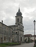
The Church of the Nativity of Our Lady was built in 1873 and was part of the Archdeaconate of Faverney of the Diocese of Besançon until 2000 . The town hall with the school ( mairie-ecole ) was built in 1830, a girls' school in 1874 and a mixed school in 1881 in the small district of Moscou .
Population development
| year | 1962 | 1968 | 1975 | 1982 | 1990 | 1999 | 2007 | 2017 | |
| Residents | 425 | 450 | 384 | 339 | 302 | 226 | 245 | 262 | |
| Sources: Cassini and INSEE | |||||||||
Attractions


- Church of the Nativity of Our Lady ( Église de la Nativité-de-Notre-Dame )
- Calvary from 1707
- The draw well, which was set up and restored next to the church in 1992, is one of several of this type that were used as cattle troughs on the high pastures of the Vôge between Gruey-lès-Surance and Vittel until the end of the 19th century.
- Church of the Nativity of Our Lady


Economy and Infrastructure
The workers in Gruey-lès-Surance are mainly employed in agriculture and forestry as well as small service companies in the village or the surrounding area. Nine farms are located in the community (dairy farming, horse and cattle breeding, sheep and goat farming). Wine is grown in the corridors of Rosemont and Le Poncé . The often noticeable blowing wind on the forest-free plateau around Gruey-lès-Surance is the reason for plans to install wind turbines.
The D 164 trunk road from Neufchâteau via Contrexéville , Darney , Bains-les-Bains to Saint-Loup-sur-Semouse is the main road through the municipality. The nearest train station (in Bains-les-Bains) is 14 kilometers southeast of Gruey-lès-Surance.
Personalities
- Ernest Gengenbach (1903–1979), French writer, surrealist
supporting documents
- ↑ toponym on cassini.ehess.fr
- ↑ Gruey-lès-Surance on cassini.ehess.fr
- ↑ Gruey-lès-Surance on insee.fr
- ↑ Farms on annuaire-mairie.fr (French)