Hautmougey
Location of Hautmougey in the Grand Est region |
Hautmougey is a former French commune in the Vosges department in the Grand Est region (until 2015 Lorraine ). It belonged to the Arrondissement Épinal and the communal association ( Communauté de communes ) Val de Vôge, founded in 2006 . Hautmougey has been part of the commune nouvelle La Vôge-les-Bains since January 1st, 2017 .
geography
Hautmougey is located at an average altitude of 233 m above sea level, five kilometers northwest of Bains-les-Bains and 35 kilometers southwest of Épinal near the border with the Bourgogne-Franche-Comté region .
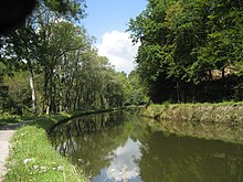
The almost eight square kilometers large former municipal area lies on the plateau of the Vôge and bordered in the east on the Côney , a tributary of the upper Saône . The Ruisseau Grandrupt flows through Hautmougey and flows into the Canal des Vosges in the south of the district . The canal runs immediately west parallel to the Côney. There are four locks on the four-kilometer-long section of the canal through Hautmougey. In the southwest, the former municipal area is bounded by the Ruisseau de Gruey , which also drains into the Canal des Vosges. To the northwest of Hautmougey, the relief rises over a step to the plateau of the Grand Bois. The highest point in the municipality was reached here at 405 meters above sea level.

The valley of the Ruisseau Grandrupt is used partly as arable land, partly as pastureland, while in the west ( Bois de Montroche ) and east ( les Chavanes ) forests dominate, which in total cover half of the municipal area.
Hautmougey consists of a settlement axis that follows the river valley of the Grandrupt in north-south direction .
Neighboring communities of Hautmougey were Harsault in the north, Les Voivres in the east, Bains-les-Bains in the southeast, Fontenoy-le-Château in the south and Gruey-lès-Surance in the west.
history
Hautmougey first appeared in a document in 1611 as Haulmougey . Until the French Revolution, the area of today's municipality belonged to the Bailiwick of Vesoul in Franche-Comté , in 1790 it moved to the canton of Bains-les-Bains in what was then the district of Darney . Until the church was built in 1856, the villagers were parish in the neighboring town of Harsault . The town hall school (maire-école) was built in 1857, followed by the construction of the girls' school in 1872.
| year | 1962 | 1968 | 1975 | 1982 | 1990 | 1999 | 2006 | 2014 | |
| Residents | 147 | 188 | 149 | 142 | 133 | 134 | 148 | 141 | |
| Source: Cassini | |||||||||
Attractions
- Saint-Luc church
- Thermal spring on the road to Fontenoy-le-Château
Economy and Infrastructure
The inhabitants of Hautmougey are mainly employed in agriculture (cereal cultivation, dairy farming, beekeeping), forestry and small service companies in the town or the surrounding area.
The D 164 trunk road from Neufchâteau via Contrexéville , Darney and Bains-les-Bains to Saint-Loup-sur-Semouse runs immediately west of Hautmougey as a bypass road through the town. The nearest train station (Bains-les-Bains) is nine kilometers southeast of Hautmougey.
supporting documents
- ↑ Hautmougey on vosges-archives.com ( Memento of the original from May 18, 2015 in the Internet Archive ) Info: The archive link was inserted automatically and has not yet been checked. Please check the original and archive link according to the instructions and then remove this notice. (French)
- ↑ Hautmougey on cassini.ehess.fr

