Begnécourt
| Begnécourt | ||
|---|---|---|

|
|
|
| region | Grand Est | |
| Department | Vosges | |
| Arrondissement | Epinal | |
| Canton | Darney | |
| Community association | Mirecourt Dompaire | |
| Coordinates | 48 ° 12 ' N , 6 ° 10' E | |
| height | 283-366 m | |
| surface | 4.57 km 2 | |
| Residents | 157 (January 1, 2017) | |
| Population density | 34 inhabitants / km 2 | |
| Post Code | 88260 | |
| INSEE code | 88047 | |
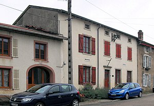
 Town hall and school building in Begnécourt |
||
Begnécourt is a French commune in the Vosges department of the Grand Est region (until 2015 Lorraine ). It belongs to the Arrondissement Épinal and the Canton Dompaire .
geography
The municipality with 157 inhabitants (January 1, 2017) is located between Épinal and Vittel .
The Madon River forms the western boundary of the municipality. Neighboring municipalities to Begnécourt are Hagécourt in the north, Dompaire in the northeast, Gelvécourt-et-Adompt in the east, Légéville-et-Bonfays in the south and Bainville-aux-Saules in the west.
history
The community was first mentioned in 1289 as Bigneicourt .
Population development
| year | 1793 | 1896 | 1954 | 1962 | 1968 | 1975 | 1982 | 1990 | 1999 | 2006 | 2015 |
| Residents | 224 | 236 | 148 | 156 | 137 | 124 | 120 | 123 | 141 | 164 | 168 |
