Canton Dompaire
| Former Canton of Dompaire |
|
|---|---|
| region | Lorraine |
| Department | Vosges |
| Arrondissement | Epinal |
| main place | Dompaire |
| Dissolution date | March 29, 2015 |
| Residents | 5,981 (Jan 1, 2012) |
| Population density | 27 inhabitants / km² |
| surface | 223 km² |
| Communities | 30th |
| INSEE code | 8811 |
The canton Dompaire was a French canton in the Arrondissement Épinal , in the Département Vosges and in the Lorraine region until 2015 ; its main town was Dompaire . The last representative in the General Council of the Department was Gérard Marulier ( DVD ) from 2011 to 2015 .
location
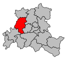
The canton was in the center of the Vosges department.
Communities
The canton consisted of thirty municipalities:
| local community | Population year | Area km² | Population density | Code INSEE | Post Code |
|---|---|---|---|---|---|
| Les Ableuvenettes | 76 (2013) | 4.49 | 17 inhabitants / km² | 88001 | 88270 |
| Ahéville | 57 (2013) | 5.84 | 10 inhabitants / km² | 88002 | 88500 |
| Bainville-aux-Saules | 132 (2013) | 5.61 | 24 inhabitants / km² | 88030 | 88270 |
| Bazegney | 115 (2013) | 5.81 | 20 inhabitants / km² | 88041 | 88270 |
| Begnécourt | 171 (2013) | 4.57 | 37 inhabitants / km² | 88047 | 88270 |
| Bettegney-Saint-Brice | 156 (2013) | 5.32 | 29 inhabitants / km² | 88055 | 88450 |
| Bocquegney | 124 (2013) | 4.57 | 27 inhabitants / km² | 88063 | 88270 |
| Bouxières-aux-Bois | 137 (2013) | 7.68 | 18 inhabitants / km² | 88069 | 88270 |
| Bouzemont | 57 (2013) | 4.97 | 11 inhabitants / km² | 88071 | 88270 |
| Circourt | 77 (2013) | 5.93 | 13 inhabitants / km² | 88103 | 88270 |
| Damas-et-Bettegney | 367 (2013) | 15.07 | 24 inhabitants / km² | 88122 | 88270 |
| Derbamont | 94 (2013) | 6.83 | 14 inhabitants / km² | 88129 | 88270 |
| Dompaire | 1,139 (2013) | 16.63 | 68 inhabitants / km² | 88151 | 88270 |
| Gelvécourt-et-Adompt | 100 (2013) | 3.94 | 25 inhabitants / km² | 88192 | 88270 |
| Gorhey | 177 (2013) | 6.31 | 28 inhabitants / km² | 88210 | 88270 |
| Gugney-aux-Aulx | 149 (2013) | 8.67 | 17 inhabitants / km² | 88223 | 88450 |
| Hagécourt | 114 (2013) | 7.6 | 15 inhabitants / km² | 88226 | 88270 |
| Harol | 610 (2013) | 27.34 | 22 inhabitants / km² | 88233 | 88270 |
| Hennecourt | 353 (2013) | 7.17 | 49 inhabitants / km² | 88237 | 88270 |
| Jorxey | 87 (2013) | 5.4 | 16 inhabitants / km² | 88254 | 88500 |
| Légéville-et-Bonfays | 48 (2013) | 5.21 | 9 inhabitants / km² | 88264 | 88270 |
| Madegney | 101 (2013) | 3.05 | 33 inhabitants / km² | 88280 | 88450 |
| Madonne-et-Lamerey | 375 (2013) | 7.02 | 53 inhabitants / km² | 88281 | 88270 |
| Maroncourt | 12 (2013) | 2.24 | 5 inhabitants / km² | 88288 | 88270 |
| Racécourt | 162 (2013) | 7.23 | 22 inhabitants / km² | 88365 | 88270 |
| Regney | 88 (2013) | 3.9 | 23 inhabitants / km² | 88378 | 88450 |
| Saint-Vallier | 111 (2013) | 4.44 | 25 inhabitants / km² | 88437 | 88270 |
| Vaubexy | 127 (2013) | 6.52 | 19 inhabitants / km² | 88494 | 88500 |
| Velotte-et-Tatignécourt | 149 (2013) | 5.36 | 28 inhabitants / km² | 88499 | 88270 |
| Ville-sur-Illon | 543 (2013) | 17.89 | 30 inhabitants / km² | 88508 | 88270 |
Population development
| 1962 | 1968 | 1975 | 1982 | 1990 | 1999 | 2006 | 2012 |
|---|---|---|---|---|---|---|---|
| 6,037 | 5,650 | 5,092 | 4,961 | 5,150 | 5,299 | 5,607 | 5,981 |
Coordinates: 48 ° 13 ' N , 6 ° 12' E

