
Canton of Lamarche
| Former canton of Lamarche |
|
|---|---|
| region | Lorraine |
| Department | Vosges |
| Arrondissement | Neufchâteau |
| main place | Lamarche |
| Dissolution date | March 29, 2015 |
| Residents | 4,543 (Jan 1, 2012) |
| Population density | 16 inhabitants / km² |
| surface | 289.03 km² |
| Communities | 26th |
| INSEE code | 8815 |
The canton of Lamarche was a French canton in the Arrondissement Neufchâteau , in the Département Vosges and in the Lorraine region until 2015 ; its main town was Lamarche . The last representative in the General Council of the Département was Serge Gérard Sancho (also UMP) from 2008 to 2015.
location
The canton was in the southwest of the Vosges department.
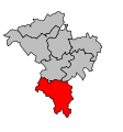
Location of the canton of Lamarche within the arrondissement of Neufchâteau
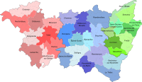
Location of the canton of Lamarche within the Vosges department


Communities
The canton consisted of 26 municipalities:
| local community | Population year | Area km² | Population density | Code INSEE | Post Code |
|---|---|---|---|---|---|
| Ainvelle | 167 (2013) | 9.03 | 18 inhabitants / km² | 88004 | 88320 |
| Blevaincourt | 102 (2013) | 8.75 | 12 inhabitants / km² | 88062 | 88320 |
| Châtillon-sur-Saône | 140 (2013) | 9.21 | 15 inhabitants / km² | 88096 | 88410 |
| Damblain | 254 (2013) | 13.27 | 19 inhabitants / km² | 88123 | 88320 |
| Fouchécourt | 45 (2013) | 4.66 | 10 inhabitants / km² | 88179 | 88320 |
| Frain | 139 (2013) | 7.54 | 18 inhabitants / km² | 88180 | 88320 |
| Grignoncourt | 41 (2013) | 5.41 | 8 inhabitants / km² | 88220 | 88410 |
| Isches | 168 (2013) | 13.6 | 12 inhabitants / km² | 88248 | 88320 |
| Lamarche | 983 (2013) | 33.69 | 29 inhabitants / km² | 88258 | 88320 |
| Lironcourt | 74 (2013) | 4.84 | 15 inhabitants / km² | 88272 | 88410 |
| Marey | 74 (2013) | 7.9 | 9 inhabitants / km² | 88287 | 88320 |
| Martigny-les-Bains | 812 (2013) | 29.22 | 28 inhabitants / km² | 88289 | 88320 |
| Mont-lès-Lamarche | 102 (2013) | 7.1 | 14 inhabitants / km² | 88307 | 88320 |
| Morizécourt | 116 (2013) | 10.68 | 11 inhabitants / km² | 88314 | 88320 |
| Robécourt | 114 (2013) | 8.78 | 13 inhabitants / km² | 88390 | 88320 |
| Rocourt | 27 (2013) | 1.86 | 15 inhabitants / km² | 88392 | 88320 |
| Romain-aux-Bois | 47 (2013) | 8.14 | 6 inhabitants / km² | 88394 | 88320 |
| Rozières-sur-Mouzon | 72 (2013) | 4.78 | 15 inhabitants / km² | 88404 | 88320 |
| Saint-Julien | 124 (2013) | 14.11 | 9 inhabitants / km² | 88421 | 88410 |
| Senaide | 175 (2013) | 12.17 | 14 inhabitants / km² | 88450 | 88320 |
| Serécourt | 125 (2013) | 13.7 | 9 inhabitants / km² | 88455 | 88320 |
| Serocourt | 98 (2013) | 11.05 | 9 inhabitants / km² | 88456 | 88320 |
| Les Thons | 119 (2013) | 10.09 | 12 inhabitants / km² | 88471 | 88410 |
| Tignécourt | 118 (2013) | 18.97 | 6 inhabitants / km² | 88473 | 88320 |
| Tollaincourt | 100 (2013) | 12.27 | 8 inhabitants / km² | 88475 | 88320 |
| Villotte | 154 (2013) | 8.21 | 19 inhabitants / km² | 88510 | 88320 |
Population development
| 1962 | 1968 | 1975 | 1982 | 1990 | 1999 | 2006 | 2012 |
|---|---|---|---|---|---|---|---|
| 6,956 | 6,726 | 6,604 | 6.237 | 5,521 | 5,046 | 4,882 | 4,543 |