Damblain
| Damblain | ||
|---|---|---|

|
|
|
| region | Grand Est | |
| Department | Vosges | |
| Arrondissement | Neufchâteau | |
| Canton | Darney | |
| Community association | Vosges Côté Sud Ouest | |
| Coordinates | 48 ° 8 ' N , 5 ° 41' E | |
| height | 328-411 m | |
| surface | 13.27 km 2 | |
| Residents | 254 (January 1, 2017) | |
| Population density | 19 inhabitants / km 2 | |
| Post Code | 88320 | |
| INSEE code | 88123 | |
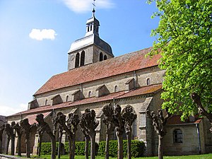
 Saint-Bénigne church |
||
Damblain is a French commune with 254 inhabitants (as of January 1, 2017) in the Vosges department in the Grand Est region (until 2015: Lorraine ). The municipality belongs to the Arrondissement Neufchâteau and to the municipality association Vosges Côté Sud Ouest, founded in 2017 . The inhabitants are called Damblinois (es) .
geography
The municipality of Damblain is located on the eastern edge of the Bassigny landscape , about 27 kilometers southwest of Vittel . Damblain borders the Haute-Marne department to the west and south . The Ruisseau de Follot stream rises in the west of the municipality and drains over the Flambart to the Meuse ; in the east the streams flow over the Mouzon to the Meuse. The undulating ground relief around the village of Damblain is predominantly characterized by arable land, while in the east the rising terrain is covered by forests ( Bois Mitreux ). Damblain is surrounded by the neighboring communities of Germainvilliers in the north, Blevaincourt and Tollaincourt in the northeast, Romain-aux-Bois in the east and Breuvannes-en-Bassigny in the south and west.
Population development
For a long time Damblain had just under a thousand inhabitants (in 1836 there were 999 inhabitants). The mechanization of agriculture encouraged emigration and the closure of the NATO air base caused the population to shrink further.
| year | 1962 | 1968 | 1975 | 1982 | 1990 | 1999 | 2008 | 2013 | |
| Residents | 545 | 511 | 507 | 443 | 353 | 302 | 288 | 254 | |
| Sources: Cassini and INSEE | |||||||||
Attractions
- Saint-Bénigne church, Monument historique
- Water tower
Economy and Infrastructure
In Damblain there are, in addition to some local small businesses, ten farms (dairy farming, cattle breeding).
Damblain station is on the Merrey – Hymont-Mattaincourt railway line, which is no longer used by passengers . Seven kilometers north of Damblain there is a connection to the A31 autoroute , which touches the west of the municipality.
Damblain military airfield
The southern base aérienne de Damblain (former ICAO code LFYD ) was most recently a military airfield of the French Air Force . The original airfield was built in 1936 and was used by the German Air Force during World War II .
During the Wehrmacht's western campaign , a hunting group equipped with MS.406 , the Groupe de chasse GC I / 2, was located here .
The NATO alternative or reserve airfield suitable for jets was created in 1953/54 after the beginning of the Cold War . From 1954 the main user of the 302 hectare base was the 3rd Fighter Squadron ( 3e Escadre de Chasse ), which was in Reims until 1961 and has since been stationed in Nancy-Ochey . At the two ends of the 2,400 m long runway there were a total of three margarite-shaped parking areas for three squadrons. The French military continued to entertain him even after leaving NATO's military structures in 1966. Military use did not end until 2005.
Then the demolition of the runway, taxiways and parking spaces for a planned logistics area began. Among other things, the logistics group Deret was interested in the location, which promised 1,500 jobs in the medium term. The departments of Vosges and Haute-Marne have already invested several million euros in the renovation of the site and a rail connection. In 2010 Deret withdrew, the demolition was stopped and no successor solution had been found until 2016, so the former airfield area is still waiting for a new use.
Personalities
- Pierre Woeiriot de Bouzey (1532–1599), died in Damblain, French painter, engraver and medalist
- Charles Renard (1847–1905), born in Damblain, French airship pioneer
supporting documents
- ↑ Damblain on cassini.ehess.fr
- ↑ Damblain on insee.fr
- ^ Entry in the Base Mérimée of the Ministry of Culture. Retrieved September 12, 2016 (French).
- ↑ Farms on annuaire-mairie.fr (French)
- ^ "Airfield desert for 40 years" , article in the daily newspaper Vosges Matin ; online at www.vosgesmatin.fr, accessed on August 8, 2016 (French)
