Trampot
| Trampot | ||
|---|---|---|

|
|
|
| region | Grand Est | |
| Department | Vosges | |
| Arrondissement | Neufchâteau | |
| Canton | Neufchâteau | |
| Community association | Ouest Vosgien | |
| Coordinates | 48 ° 22 ' N , 5 ° 26' E | |
| height | 364-441 m | |
| surface | 13.14 km 2 | |
| Residents | 92 (January 1, 2017) | |
| Population density | 7 inhabitants / km 2 | |
| Post Code | 88350 | |
| INSEE code | 88477 | |
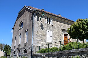
 Mairie trampot |
||
Trampot is a French commune in the Vosges department in the region of Grand Est (2015 Lorraine ). It belongs to the Arrondissement of Neufchâteau and the Canton of Neufchâteau . The residents call themselves trampotins . Trampot is passed by the former Route nationale 427 .
geography
The municipality of Trampot is located in the extreme west of the Vosges department in a wooded area. The surrounding area is karst, with precipitation seeping into the ground. During heavy rain, the water makes its way through dry valleys towards the west. This makes Trampot the only municipality in the department that belongs to the Seine catchment area . The adjacent parishes are Grand , Brechainville , Aillianville , Chambroncourt, and Morionvilliers .
Population development
| year | 1962 | 1968 | 1975 | 1982 | 1990 | 1999 | 2008 | 2017 |
|---|---|---|---|---|---|---|---|---|
| Residents | 210 | 204 | 167 | 159 | 150 | 126 | 112 | 92 |
Attractions
- Church Saint-Pierre et Saint-Paul , since 3 September 2010 as monument historique recognized.
- Fallen memorial
Web links
Commons : Trampot - collection of images, videos and audio files


