
Bazoilles-sur-Meuse
| Bazoilles-sur-Meuse | ||
|---|---|---|

|
|
|
| region | Grand Est | |
| Department | Vosges | |
| Arrondissement | Neufchâteau | |
| Canton | Neufchâteau | |
| Community association | Ouest Vosgien | |
| Coordinates | 48 ° 18 ′ N , 5 ° 40 ′ E | |
| height | 284-408 m | |
| surface | 21.25 km 2 | |
| Residents | 598 (January 1, 2017) | |
| Population density | 28 inhabitants / km 2 | |
| Post Code | 88300 | |
| INSEE code | 88044 | |
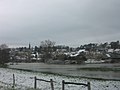
 The Meuse at Bazoilles-sur-Meuse |
||

Bazoilles-sur-Meuse is a French commune with 598 inhabitants (as of January 1, 2017) in the Vosges department in the Grand Est region (until 2015 Lorraine ). Bazoilles-sur-Meuse belongs to the Arrondissement of Neufchâteau and the Canton of Neufchâteau .
geography
The municipality of Bazoilles-sur-Meuse is located on the upper Meuse , about eight kilometers south of Neufchâteau . The Meuse seeps into the calcareous rock here and only reappears on the surface five kilometers further north. Bazoilles is surrounded by the neighboring communities Neufchâteau in the north, Circourt-sur-Mouzon in the east, Pompierre in the southeast, Harréville-les-Chanteurs (in the Haute-Marne department ) in the southwest, Liffol-le-Grand in the west and Fréville in the northwest.
Attractions
- Saint Martin Church
- Bazoillrs Castle from the 18th century
- Meuse infiltration
- two caves
- Water tower

Saint Martin Church
Bazoilles-sur-Meuse (April 2008)

cave
.JPG)
.jpg)
.JPG)