Tignécourt
| Tignécourt | ||
|---|---|---|
|
|
||
| region | Grand Est | |
| Department | Vosges | |
| Arrondissement | Neufchâteau | |
| Canton | Darney | |
| Community association | Vosges Côté Sud Ouest | |
| Coordinates | 48 ° 3 ' N , 5 ° 54' E | |
| height | 242-373 m | |
| surface | 18.97 km 2 | |
| Residents | 105 (January 1, 2017) | |
| Population density | 6 inhabitants / km 2 | |
| Post Code | 88320 | |
| INSEE code | 88473 | |
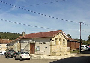
 Mairie Tignécourt |
||
Tignécourt is a French commune with 105 inhabitants (as of January 1, 2017) in the Vosges department in the Grand Est region (until 2015 Lorraine ). Tignécourt is part of the Neufchâteau arrondissement and the Darney canton .
geography
The municipality of Tignécourt is located in the Monts Faucilles near the headwaters of the Saône , about 22 kilometers south of Vittel . Tignécourt is surrounded by the neighboring communities Serocourt in the north, Bleurville in the east, Saint-Julien in the south, Fouchécourt and Isches in the south-west, Serécourt in the west and Morizécourt in the north-west. The district of Flabémont with the Flabémont monastery belongs to Tignécourt.
Population development
| year | 1962 | 1968 | 1975 | 1982 | 1990 | 1999 | 2006 | 2016 |
| Residents | 195 | 180 | 159 | 124 | 115 | 111 | 109 | 104 |
| Sources: Cassini and INSEE | ||||||||
Web links
Commons : Tignécourt - collection of images, videos and audio files


