
Aulnois (Vosges)
| Aulnois | ||
|---|---|---|

|
|
|
| region | Grand Est | |
| Department | Vosges | |
| Arrondissement | Neufchâteau | |
| Canton | Vittel | |
| Community association | Terre d'Eau | |
| Coordinates | 48 ° 15 ' N , 5 ° 47' E | |
| height | 328-430 m | |
| surface | 4.44 km 2 | |
| Residents | 161 (January 1, 2017) | |
| Population density | 36 inhabitants / km 2 | |
| Post Code | 88300 | |
| INSEE code | 88017 | |
 View of Aulnois |
||

Aulnois is a French commune with 161 inhabitants (as of January 1, 2017) in the Vosges department in the Grand Est region (until 2015 Lorraine ). Aulnois is part of the Neufchâteau arrondissement and the canton of Vittel .
geography
Aulnois lies between Neufchâteau and Vittel on the Ruisseau le Bani stream , a tributary of the Mouzon , and is affected by the former Route nationale 64 (today: D 164). Neighboring municipalities are Ollainville in the northeast, Hagnéville-et-Roncourt in the southeast, Beaufremont in the west and Landaville in the northwest.
Population development
| year | 1962 | 1968 | 1985 | 1982 | 1990 | 1999 | 2008 | 2014 |
| Residents | 141 | 146 | 149 | 134 | 141 | 123 | 148 | 156 |
Attractions
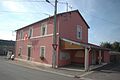
Mairie Aulnois
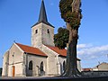
Church of Paul's Conversion ( Église de la Conversion-de-Saint-Paul )


Web links
Commons : Aulnois - collection of images, videos and audio files