
Coussey
| Coussey | ||
|---|---|---|

|
|
|
| region | Grand Est | |
| Department | Vosges | |
| Arrondissement | Neufchâteau | |
| Canton | Neufchâteau | |
| Community association | Ouest Vosgien | |
| Coordinates | 48 ° 25 ' N , 5 ° 41' E | |
| height | 267-422 m | |
| surface | 16.02 km 2 | |
| Residents | 723 (January 1, 2017) | |
| Population density | 45 inhabitants / km 2 | |
| Post Code | 88630 | |
| INSEE code | 88118 | |

Coussey is a commune in the Vosges department in the Grand Est region (until 2015 Lorraine ); it belongs to the Arrondissement Neufchâteau and the municipality association Ouest Vosgien .
geography
The community of Coussey, with 723 inhabitants (as of January 1, 2017), is located about 40 kilometers south of Toul , not far from the border with the Meurthe-et-Moselle department . The closest small town is Neufchâteau , six kilometers away.
The upper Meuse flows through the municipality from south to north and, with numerous bends in the river and the two inland islands Le Closelot and L'Îlotte, forms a valley about 1500 meters wide. The Vair flows into the Meuse at the northern edge of the municipality and the Saônelle at the southern end . The approximately 16 km² municipal area of Coussey is mainly characterized by meadows and fields in the valley area around the village, while forests dominate in the west ( Bois de Coussey and Bois des Combelles ). The banks of the Meuse are approx. 270 m ; the hills to the west of the Meuse reach heights of a maximum of 422 m . The elevations are part of the 200 km long Côtes de Meuse ridge .
The district of La Croix Noire belongs to Coussey and was built across the main settlement axis following the right bank of the Meuse.
Neighboring municipalities to Coussey are (clockwise, starting from the north) Domrémy-la-Pucelle , Maxey-sur-Meuse , Moncel-sur-Vair , Soulosse-sous-Saint-Élophe , Neufchâteau , Frebécourt , Sionne and Seraumont .
history
The place was called Cussiacum in medieval Latin . Linguists of the 19th century made a connection with the Gallic personal name Coccius . The municipality of Coussey in its current form was established on August 17, 1736 as part of the Bailiwick of Neufchâteau. The church belonged to the deanery Neufchâteau in the diocese of Toul, from 1778 to the newly founded diocese of Saint-Dié. The parish was under the influence of the Abbot of St. Mansuy ( Mansuetus ).
coat of arms
The coat of arms of the municipality of Coussey - adopted in 1866 on the occasion of the 100th anniversary of the annexation of the Duchy of Lorraine to France - shows in the right half part of the coat of arms of the Grafschaft Bar , on the left the red sloping bar with three silver mutilated eagles on a gold shield Lorraine coat of arms. In the middle of the coat of arms a blue crescent moon, which is supposed to commemorate a trip by the Toulon Count Mathieu de Lorraine to the Holy Land in 1214. Instead of the crescent there is also an interpretation as uppercase C for C oussey.
Population development
| year | 1962 | 1968 | 1975 | 1982 | 1990 | 1999 | 2008 | 2017 | |
| Residents | 640 | 629 | 619 | 757 | 752 | 707 | 715 | 723 | |
| Sources: Cassini and INSEE | |||||||||
Attractions
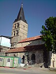
- Church of the Assumption ( Église de l'Assomption-de-Notre-Dame ) from the 12th century, when historique monument classified
- Lavoir
- Church of the Assumption in Coussey


Parish partnership
Coussey has a partnership with the Belgian municipality of Anthisnes .
Economy and Infrastructure
Nine farms are located in the community (cereal and vegetable growing, dairy farming). Many residents commute to the nearby town of Neufchâteau or work in the tourism sector (accommodating numerous guests who visit the birthplace of Jeanne d'Arc in the small neighboring village of Domrémy-la-Pucelle ). Coussey has a post office and is also a kindergarten and elementary school location as well as the location of a gendarmerie brigade .
Transport links
The D164 trunk road leads through Coussey from Bains-les-Bains via Darney , Contrexéville and Neufchâteau to Commercy (and following the Meuse valley to Verdun ). There are other road links to Gironcourt-sur-Vraine and Liffol-le-Grand . 24 kilometers south-east of Coussey is the next slip road to the A31 ( Toul - Dijon ). The former Cossey station, reminiscent of a street, the Rue de la Gare , was on the railway line from Neufchâteau via Vaucouleurs to Pagny-sur-Meuse , which opened in 1873 and which was closed for passenger traffic in 1990. The remaining freight traffic on the 7.5-kilometer section from Neufchâteau to Coussey is operated by SNCF .
supporting documents
- ↑ Coussey on vosges-archives.com ( Memento of the original from December 15, 2013 in the Internet Archive ) Info: The archive link was inserted automatically and has not yet been checked. Please check the original and archive link according to the instructions and then remove this notice. (PDF file, French)
- ↑ Description of the coat of arms on genealogie-lorraine.fr (French)
- ↑ Coussey on cassini.ehess.fr
- ↑ Coussey on insee.fr
- ^ Entry in the Base Mérimée of the Ministry of Culture. Retrieved December 15, 2013 (French).
- ↑ Picture of the lavoir in Coussey
- ↑ Farms on annuaire-mairie.fr (French)
- ↑ André Schontz, Arsène Felten, Marcel Gourlot: Le Chemin de fer de Lorraine. Editions Serpenoise, 1999, ISBN 2-87692-414-5 .