
Serécourt
| Serécourt | ||
|---|---|---|

|
|
|
| region | Grand Est | |
| Department | Vosges | |
| Arrondissement | Neufchâteau | |
| Community association | Vosges Côté Sud Ouest | |
| Coordinates | 48 ° 3 ' N , 5 ° 51' E | |
| height | 280-478 m | |
| surface | 13.7 km 2 | |
| Residents | 100 (January 1, 2017) | |
| Population density | 7 inhabitants / km 2 | |
| Post Code | 88320 | |
| INSEE code | 88455 | |
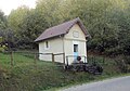
 Mairie Serécourt |
||

Serécourt is a French commune with 100 inhabitants (as of January 1, 2017) in the Vosges department in the Grand Est region (until 2015 Lorraine ). It belongs to the Arrondissement Neufchâteau and the municipality association Vosges Côté Sud Ouest .
geography
The municipality of MSerécourt is located about 20 kilometers south-south-west of Vittel in the extreme south-west of Lorraine. Three kilometers northwest of Derécourt runs the Maas - Saône - watershed . The Heuyon (487 meters above sea level) is one of the highest elevations between the Langres plateau and the Vosges .
Neighboring municipalities of Serécourt are Morizécourt in the north, Tignécourt in the east, Isches in the south and Lamarche in the west.
Population development
| year | 1962 | 1968 | 1975 | 1982 | 1990 | 1999 | 2006 | 2017 | |
| Residents | 211 | 197 | 190 | 163 | 125 | 103 | 108 | 100 | |
| Sources: Cassini and INSEE | |||||||||
Attractions
- Church of St. Petronilla and St. Mansuetus
- Lavoir and washing area
- Notre-Dame-de-Deuilly chapel

Church of St. Petronilla and St. Mansuetus

Lavoir on rue du Paquis

Washing area on Rue du Heuyon
Notre-Dame-de-Deuilly chapel


Economy and Infrastructure
Ten farms are located in the municipality (grain cultivation, dairy farming, breeding of cattle, sheep and goats).
The D 32 trunk road from Charmes to Rambervillers runs through the municipality of Essegney . In the nearby town of Charmes there is a connection to the motorway-like RN 57 from Nancy to Épinal . Charmes station, one and a half kilometers from Essegney, is on the Blainville-Damelevières-Lure railway line .