Houécourt
| Houécourt | ||
|---|---|---|

|
|
|
| region | Grand Est | |
| Department | Vosges | |
| Arrondissement | Neufchâteau | |
| Canton | Mirecourt | |
| Community association | Terre d'Eau | |
| Coordinates | 48 ° 18 ' N , 5 ° 54' E | |
| height | 306-398 m | |
| surface | 9.91 km 2 | |
| Residents | 440 (January 1, 2017) | |
| Population density | 44 inhabitants / km 2 | |
| Post Code | 88170 | |
| INSEE code | 88241 | |
 Location of the commune of Houécourt in the Vosges department |
||
Houécourt is a French commune with 440 inhabitants (January 1, 2017) in the Vosges department in the Grand Est region . It is part of the Neufchâteau arrondissement and the Terre d'Eau municipality .
geography
The municipality of Houécourt is located at about 320 to 330 m a.s.l. in the south of Lorraine, halfway between Neufchâteau and Mirecourt , more spaciously about 45 kilometers south of Toul . The village extends in the transition area between the Bassigny as part of the plateau of Langres and the Xaintois . The river valleys, which fan-shaped towards the upper Meuse, are characteristic of the area .
The area of the almost ten square kilometers large municipal area includes a section of the gently undulating landscape in the area of the Maas tributary Vair , whose winding course limits the municipality to the west and south-west. In the area of the municipality, the Ruisseau de Rainvaux stream flows into the Vair from the southeast. The gentle valleys are flanked by partially wooded hills. The municipality includes the Bois Louvrois forest in the northeast and the almost 300 hectare Bois de la Voivre forest in the southeast. Over half of the community area is available for agriculture.
Neighboring municipalities of Houécourt are Morelmaison in the north, Gironcourt-sur-Vraine in the east, Dombrot-dur-Vair in the south, La Neuveville-sous-Châtenois in the west and Châtenois and Viocourt in the north-west.
history
Before the French Revolution, Houécourt belonged to the Bailiwick of Neufchâteau .
A county of Houécourt was established in 1719, which two years later became a margraviate. The counts provided the long-established Lignéville family .
The parish of Houécourt was under the patronage of the Abbot of Saint-Mihiel , who claimed two thirds of the tithe .
Population development
| year | 1962 | 1968 | 1975 | 1982 | 1990 | 1999 | 2007 | 2017 | |
| Residents | 485 | 488 | 474 | 418 | 365 | 386 | 432 | 440 | |
| Sources: Cassini and INSEE | |||||||||
Attractions
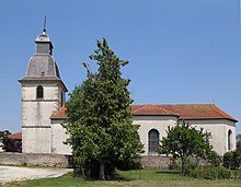
- St. Quentin's Church from the 18th century
- small chapel from 1546 (the Duke of Choiseul-Stainville was buried here in 1838)
Economy and Infrastructure
Agriculture still plays a role in Houécourt today. There are seven farms in the municipality (breeding horses, sheep and goats). There are also small trade and craft businesses. Some residents commute to the BSN Glasspack plant in the neighboring community of Gironcourt-sur-Vraine , which has been part of the Owens-Illinois group since 2004 .
The D 166 trunk road from Épinal to Neufchâteau, which is partially two-lane and free of intersections, bypasses the community in the south. It crosses the Autoroute A 31 ( Toul - Dijon ) west of Houécourt . The motorway junction set up here is one of three connections in the Vosges department and an important regional transport hub.
supporting documents
- ↑ Houécourt on vosges-archives.com. (pdf; 122 kB) (No longer available online.) Archived from the original on December 7, 2015 ; Retrieved June 29, 2011 (French).
- ↑ Statistics from 1793 Houécourt on cassini.ehess.fr
- ↑ Houécourt on insee.fr
- ↑ Farms on annuaire-mairie.fr (French)

