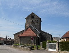
Saint-Ouen-lès-Parey
| Saint-Ouen-lès-Parey | ||
|---|---|---|
|
|
||
| region | Grand Est | |
| Department | Vosges | |
| Arrondissement | Neufchâteau | |
| Canton | Vittel | |
| Community association | Terre d'Eau | |
| Coordinates | 48 ° 11 ′ N , 5 ° 46 ′ E | |
| height | 322-435 m | |
| surface | 21.09 km 2 | |
| Residents | 495 (January 1, 2017) | |
| Population density | 23 inhabitants / km 2 | |
| Post Code | 88140 | |
| INSEE code | 88430 | |
 Saint-Ouen-lès-Parey town hall |
||
Saint-Ouen-lès-Parey is a French commune with 495 inhabitants (January 1, 2017) in the Vosges department in the Grand Est region ( Lorraine until 2015 ). It is part of the Neufchâteau arrondissement and the Terre d'Eau community association founded in 2017 . The inhabitants are called Odéens .
geography
The municipality is located about 20 kilometers west of Vittel in the extreme southwest of Lorraine between the regions of Bassigny in the southwest and Xaintois in the northeast. From the southeast, the foothills of the Monts Faucilles extend over to the municipal area (in the Bois de la Bouloie , the highest point is reached at 435 m above sea level). The Anger flows through the municipality , a tributary of the Mouzon , which belongs to the catchment area of the Meuse . About a third of the 21.09 km² large community area is covered with forest, which extends to the south and east.
Neighboring communities of Saint-Ouen-lès-Parey are Aingeville in the north, Saulxures-lès-Bulgnéville in the east, Crainvilliers in the south-east, La Vacheresse-et-la-Rouillie in the south, Sauville in the south-west and Urville in the north-west.
The A31 autoroute (Dijon-Nancy-Metz-Luxemburg) runs along the north-western edge of the municipality .
history
The municipality of Saint-Ouen-lès-Parey was created by royal decree of March 5, 1833 from the previously independent municipalities of Saint-Ouen and Parey, which at that time had almost grown together. Early spellings of Saint-Ouen were Sancta Oda, Saint-Ouïn, Saint-Ouain and Saint-Ouyn . Lords of Saint-Ouen were the Espine, Mathey, Châtelet, Torneille, Lavaux, d'Orbilly and Bresson families in the 200 years before the revolution .
The parish of the Church of St. Ode and Holy Trinity in Saint-Ouen was merged with the parish of the Church of Our Lady in Parey in the 12th century .
The Mairie (town hall) was built in 1800, the boys 'and girls' schools were built in 1835.
Many documents about the history of the community were destroyed in a fire in the town hall in the middle of the 20th century.
Population development
| year | 1962 | 1968 | 1975 | 1982 | 1990 | 1999 | 2006 | 2017 | |
| Residents | 568 | 558 | 553 | 518 | 575 | 539 | 501 | 495 | |
| Sources: Cassini and INSEE | |||||||||
Attractions
- Church of Sainte-Ode et Sainte-Trinité in Saint-Ouen from the 12th century (Gothic nave), restored in the 17th century, Monument historique
- Church of Our Lady in Parey
- Castle ( Château de Saint-Ouen ) from the 18th century
- Fountain
- 16th century wayside cross, Monument historique
- Jardin d'Ode - publicly accessible garden with the rating Jardin remarquable
Economy and Infrastructure
Nine farms are located in Saint-Ouen-lès-Parey [cereal growing, dairy farming, cattle, goat and sheep breeding]. In addition, services and trade play a certain role.
Transport links
The D17 road leads from Bulgnéville to Vrécourt through Saint-Ouen-lès-Parey . In Bulgnéville there is a connection to the A31 . The nearest rail connection is in Contrexéville, 13 kilometers away on the railway line from Nancy to Culmont - Chalindrey .
supporting documents
- ↑ Saint-Ouen-lès-Parey on vosges-archives.com ( Memento of the original from March 3, 2016 in the Internet Archive ) Info: The archive link has been inserted automatically and has not yet been checked. Please check the original and archive link according to the instructions and then remove this notice. , PDF file, French, accessed March 30, 2015
- ↑ Saint-Ouen-lès-Parey on cassini.ehess.fr
- ↑ Saint-Ouen-lès-Parey on insee.fr
- ^ Entry in the Base Mérimée of the Ministry of Culture. Retrieved March 30, 2015 (French).
- ^ Entry in the Base Mérimée of the Ministry of Culture. Retrieved March 30, 2015 (French).
- ↑ Farms on annuaire-mairie.fr (French)


