
Nieuwenhagen
.png) flag |
 coat of arms |
| province |
|
| local community |
|
|
Area - land - water |
5.23 km 2 5.23 km 2 0 km 2 |
| Residents | 9,345 (Jan 1, 2018) |
| Coordinates | 50 ° 54 ' N , 6 ° 2' E |
| height | 140 m NAP |
| Important traffic route |
|
| prefix | 045 |
| Postcodes | 6373 |
 |
|


Nieuwenhagen ( Limburgish Nuijenhage , German Neuenhagen ) is a village in the Dutch province of Limburg and at the same time an official district ( "wijk" ) of the municipality of Landgraaf . Until December 31, 1981 Nieuwenhagen was an independent municipality. The town, which is about 2½ km from the German border, has a population of around 9,345.
geography
Nieuwenhagen lies on the Nieuwenhagen plateau named after it . Until the beginning of the 20th century , Nieuwenhagen was an agricultural area with predominantly smaller farms . Today (2015) Nieuwenhagen is part of the heavily urbanized municipality of Landgraaf with around 39,000 inhabitants, which in turn belongs to the so-called Parkstad Limburg , an urban region that was formerly known as Oude or Oostelijke Mijnstreek (literally: Old or Eastern Mining Area ). For this densely populated area, green spaces and natural areas such as the Brunssumer Heide, which is partly still on Nieuwenhager Terrain, are of great importance.
history
From archaeological finds it is known that people lived in the vicinity of Nieuwenhagen even in prehistoric times .
Archaeological finds from the area of Nieuwenhagen and its immediate surroundings (Strijdhagen) are also known from Roman times . A Roman country house is said to have been located on Koelweg , a side street off Hereweg , and in the 1960s the grave of a wealthy Roman lady was discovered a few hundred meters further on Hereweg .
The Romans had an extensive road network in their empire, about 80,000 km of which were in excellent condition. One of these high-quality roads was the Via Belgica , now known as it is , a Roman military road that ran from Boulogne-sur-Mer on the French Atlantic coast to Cologne . Whether and where exactly this important Roman road ran through the Nieuwenhager area is not entirely certain, because that road has not yet been excavated in this area. It is conceivable that it would run over the streets Op de Heugden , Hereweg and Haanweg , which is also indicated by the street name “ Hereweg ” (German: “ Heerweg ”). In any case, archaeological finds have confirmed that this Roman road crossed the Wurm river near Rimburg .
The origin of the place name has not yet been clarified. The first part of the name ( ndl. Nieuw = dt. New ) indicates an older settlement in the area, which was probably already called Hag or Hagen , which would then have been the older Hagen . The word " Hag " means hedge and refers to a place surrounded by a hedge, perhaps also fortified . In 1213 the name Nieuwenhagen was first mentioned in a document. This first mention was found in the proper name of a ministerial in the suite of Count Lothar von Are . A farm in Nieuwenhagen is not mentioned until the 14th century . The village probably arose over the centuries around the so-called Vaechshof (= Vogtshof ). In the Middle Ages , the later municipal area of Nieuwenhagen was part of the main lay judge's bank Heerlen , a feudal court district . By excavated there pottery and pottery - kilns are known to have lived people in Nieuwenhagen and its surroundings during the Middle Ages and worked.
During the 80 years of war changed in the area around Nieuwenhagen several times the country's sovereignty . The war caused economic problems and even after the Peace of Munster in 1648 the territorial situation in what is now South Limburg remained unclear. During the peace negotiations (in Münster), the Dutch Republic and Spain could not agree on the allocation of the three Lands van Overmaas ( Land van Valkenburg , Land van Rode and Land van Dalhem ). The Dutch Republic assumed the rule that the owner of a main town would automatically be assigned the corresponding lands. In contrast, Spain had occupied the residence of the former Duchy of Limburg , to which the three Lands of Overmaas still belonged in principle, and therefore claimed control over the entire area.
In the partition contract of 1661/62 between the Dutch Republic and Spain, the three lands of Valkenburg , Rode and Dalheim were all divided into a Dutch-republican (" State ... ") and a Spanish part. As a result of this division contract Nieuwenhagen became a part of since the so-called area of state Overmaas which in turn one of the Generality was the Dutch Republic. Despite its somewhat isolated location due to the new borders, Nieuwenhagen did not become a republican exclave in the middle of Spanish territory . Via the republican part of the Brunssumer Heide in the north or the area of Strijthagen and the Overste Hof in the southeast, one could in principle reach the republican main village Heerlen without touching Spanish (or later Austrian) soil. However, this routes led through rough terrain, and also constitute detours. For this reason, was Pasweg or Passeerweg (dt. Passport or Passierweg ) is applied, a kind of transit road running across the Spanish glory Schaesberg proceeded. It is remarkable that this path, including a 4.80 m wide strip of land on both sides of the road, was ceded by Spain to the Dutch Republic.
After the male line of the Spanish Habsburgs died out at the beginning of the 18th century, the War of the Spanish Succession broke out . After its end, after the Peace of Utrecht in 1713, most of the Spanish Netherlands came under the rule of the Austrian Habsburgs. For the already republican Nieuwenhagen, however, little changed. At that time there was no church of its own in Nieuwenhagen, the predominantly Roman Catholic population remained dependent on the parish church of St. Pankratius in Heerlen-Dorf until 1802 , for baptisms , marriages and funerals , among other things .
Nieuwenhagen only got its own chapel in 1745 . The funds for this were the ten years earlier deceased bachelors January spots testamentary provided. Although the Estates General of the Republic permitted the practice of the Roman Catholic religion with some restrictions, the construction of new churches and chapels on Dutch republican territory was prohibited. Finally, a certain Johann Arnoldus Hanssen (s) provided a remedy by ceding a piece of land, which was on the territory of the Overworms Quartier der Schöffenbank Ubach , which had been part of the Spanish part of Land van Rode since 1661 . A new chapel was built here. Although this piece of land had belonged to the Austrian Netherlands since 1713 , the area was still popularly known in Limburgish as “ Sjpaans Kentje ” (pronunciation: “ Schpaans Kentje ”, literally: “Spanish corner”). This new church building required the approval of both Emperor Charles VI. (as the supreme ruler of the then undivided Ubach / Übach ) as well as by the prince-bishop of Liège (as the responsible spiritual shepherd ).
In the 18th century, the region around Nieuwenhagen suffered greatly from the raids of the so-called Bockreiter gangs and the resulting hysterical hunts by the church and the authorities.
In 1802 Nieuwenhagen became an independent municipality within the French department of Meuse-Inférieure . From 1830 to 1839 Nieuwenhagen was like most of the South Limburg municipalities part of Belgium , by 1839 the newly founded Duchy of Limburg , which the Kingdom of the Netherlands at first only in personal union was connected until 1866 as province was part of the Netherlands again.
On January 1, 1982, a municipal reorganization took place in South Limburg , with the former municipalities of Schaesberg , Ubach over Worms and Nieuwenhagen being merged into the newly formed municipality of Landgraaf . Since then, Nieuwenhagen has been an official district (" wijk ") and one of four larger town centers in the municipality of Landgraaf.
Attractions
- Sjpaans Kentje , a chapel built in 1745/46,heavily rebuilt in 1790. It is a relatively simple brick building in a neoclassical style. The Vorgiebel has a simple frieze with one of four ionic pilasters supported tympanum of natural stone . Since the restoration in the 1980s, there is again a modest wooden roof turret on the roof.
- Onze-Lieve-Vrouw Hulp der Christenenkerk (" Maria-Hilf-Kirche "), built in 1917 by the architect Hubert van Groenendael .
- Heilig Hart Van Jezuskerk (" Herz-Jesu-Kirche "), the church building designedby Jos Wielders waserected in 1919 in what was then the new development area of Nieuwenhagerheide .
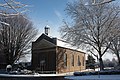
Sjpaans Kentje in winter
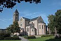
Kerk Onze-Lieve-Vrouw Hulp der Christenen ( Maria-Hilf-Kirche )

Kerk Heilig Hart van Jezus ( Church of the Sacred Heart of Jesus )

Rectory, Hoogstraat 139

.JPG)


Association
- Sportvereniging Nieuwenhagen (SVN), founded in 1934 ( football )
- RKSV Sylvia , founded 1949 (soccer)
- Gymnastiekvereniging Olympia , founded in 1907 ( gymnastics )
- Schutterij Koningin Wilhelmina , founded in 1860 ( shooting club , folklore )
- Harmonie St. Caecilia Nieuwenhagen , founded in 1890 ( brass music )
- Fanfare Eendracht Nieuwenhagerheide , founded in 1890 (brass music)
- Carnival Association Ieëre Road de Sjweëgelsöppers , founded in 1982 ( Carnival Association )
- Toneelvereniging Kiekes Wead, founded 1978 ( amateur theater )
- Oudheidkundig en Cultuurhistorisch Genootschap Landgraaf , founded in 1982 ( Heimatverein )
- Stichting Meifeesten Nieuwenhagen , founded in 1990 (folklore, culture )
Personalities born in Nieuwenhagen
- Willem Jurgens (1780–1836), offspring of the merchants and peddlers - Jurgens dynasty . Just like his father Dionysius and his younger brother Lennert, he was a “ dealer in Amsterdam for textiles and needles from Aachen ”. In 1871, the descendants of Willem Jurgens were the first toproduce margarine . After a series of mergers which arose from their holding company Unilever .
- Leni Raats (1925–2013), singer in the duo Leni & Ludwig
- Sjeng Kremers (* 1933), psychologist , administrative officer and politician, Royal Commissioner of Limburg 1977–1990
- Hein Meens (1949–2012), tenor and conductor
- Hans Zuidersma (* 1949), footballer
- Joep Lange (1954–2014), medical doctor and AIDS specialist
Web links
- Official website of the municipality of Landgraaf (German)
- History of the origins of Nieuwenhagen ( Memento from September 30, 2007 in the Internet Archive ) (Dutch)
- List of mayors of Nieuwenhagen (Dutch)
Individual evidence
- ↑ a b Kerncijfers wijken en buurten 2018 Centraal Bureau voor de Statistiek , accessed on August 1, 2018 (Dutch)
-
↑ Top 50 NRW - Official Topographic Maps North Rhine-Westphalia 1: 50000 (CD-ROM), Version 3.0,
published in 2000 by the State Surveying Office North Rhine-Westphalia ( Memento of the original from March 26, 2018 in the Internet Archive ) Info: The archive link was inserted automatically and not yet checked. Please check the original and archive link according to the instructions and then remove this notice. , Bonn-Bad Godesberg (now: Cologne District Government)