
Romain-aux-Bois
| Romain-aux-Bois | ||
|---|---|---|
|
||
| region | Grand Est | |
| Department | Vosges | |
| Arrondissement | Neufchâteau | |
| Canton | Darney | |
| Community association | Vosges Côté Sud Ouest | |
| Coordinates | 48 ° 5 ' N , 5 ° 43' E | |
| height | 337-460 m | |
| surface | 8.14 km 2 | |
| Residents | 48 (January 1, 2017) | |
| Population density | 6 inhabitants / km 2 | |
| Post Code | 88320 | |
| INSEE code | 88394 | |
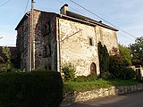
.JPG) Mairie Roman-aux-Bois |
||

Romain-aux-Bois is a French commune with 48 inhabitants (as of January 1, 2017) in the Vosges department ( Grand Est region ). Romain-aux-Bois is part of the Neufchâteau arrondissement and the Darney canton .
geography
The municipality of Romain-aux-Bois is located about 45 kilometers northeast of Langres on the border with the Haute-Marne department . Neighboring communities are Rozières-sur-Mouzon in the north, Tollaincourt in the east, Lamarche in the south-east, Breuvannes-en-Bassigny in the south-west and Damblain in the west.
Population development
| year | 1962 | 1968 | 1975 | 1982 | 1990 | 1999 | 2006 | 2016 |
| Residents | 91 | 103 | 95 | 81 | 58 | 40 | 44 | 48 |
Fortified house, 15th century
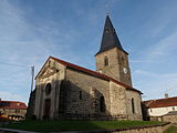
Saint-Èvre church
.JPG)
.JPG)
.JPG)
Web links
Commons : Romain-aux-Bois - collection of images, videos and audio files