
Attignéville
| Attignéville | ||
|---|---|---|
|
||
| region | Grand Est | |
| Department | Vosges | |
| Arrondissement | Neufchâteau | |
| Canton | Neufchâteau | |
| Community association | Ouest Vosgien | |
| Coordinates | 48 ° 23 ' N , 5 ° 49' E | |
| height | 295-450 m | |
| surface | 14.61 km 2 | |
| Residents | 217 (January 1, 2017) | |
| Population density | 15 inhabitants / km 2 | |
| Post Code | 88300 | |
| INSEE code | 88015 | |
 Mairie Attignéville |
||

Attignéville is a French commune with 217 inhabitants (as of January 1, 2017) in the Vosges department in the Grand Est region (until 2015 Lorraine ). Attignéville belongs to the Arrondissement Neufchâteau and the Canton of Neufchâteau .
geography
Attignéville is located on the Vair , a tributary of the Meuse, and is about 13 kilometers from Neufchâteau and 61 kilometers from Épinal . Attignéville is surrounded by the neighboring communities Tranqueville and Gémonville in the northeast, Aouze in the east, Removille in the southeast, Houéville in the south, Barville in the southwest and Harchéchamp in the west.

Saint-Lambert Church, south-west side
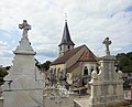
Saint-Lambert Church, east side

Interior view of Saint-Lambert
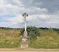
Monumental cross


Web links
Commons : Attignéville - Collection of images, videos and audio files