Autreville (Vosges)
| Autreville | ||
|---|---|---|
|
|
||
| region | Grand Est | |
| Department | Vosges | |
| Arrondissement | Neufchâteau | |
| Canton | Neufchâteau | |
| Community association | Ouest Vosgien | |
| Coordinates | 48 ° 29 ' N , 5 ° 51' E | |
| height | 287-364 m | |
| surface | 11.09 km 2 | |
| Residents | 183 (January 1, 2017) | |
| Population density | 17 inhabitants / km 2 | |
| Post Code | 88300 | |
| INSEE code | 88020 | |
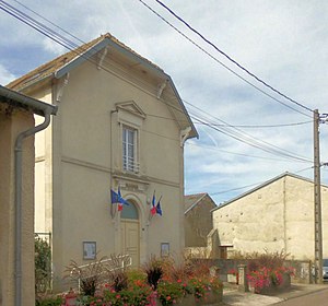
 Mairie Autreville |
||
Autreville is a French commune with 183 inhabitants (as of January 1, 2017) in the Vosges in the Grand Est region (until 2015 Lorraine ). It belongs to the Arrondissement Neufchâteau and the municipality association Ouest Vosgien .
geography
Autreville is the northernmost commune of the Vosges department on the border with the Meurthe-et-Moselle department . The Aroffe flows in the chalky subsoil of the municipality . In the north-west of the municipality the Roman road Via Agrippa runs from Lyon to Trier; through the wooded northwest the autoroute A31 . Neighboring communities of Autreville are Barisey-au-Plain in the north, Colombey-les-Belles and Selaincourt in the north-east, Harmonville in the south-east, Punerot in the west and Saulxures-lès-Vannes in the north-west.
Attractions
- Saint-Brice church
- Joan of Arc monument
- Water tower


