Greux
| Greux | ||
|---|---|---|
|
|
||
| region | Grand Est | |
| Department | Vosges | |
| Arrondissement | Neufchâteau | |
| Canton | Neufchâteau | |
| Community association | Ouest Vosgien | |
| Coordinates | 48 ° 27 ' N , 5 ° 41' E | |
| height | 264-411 m | |
| surface | 8.08 km 2 | |
| Residents | 157 (January 1, 2017) | |
| Population density | 19 inhabitants / km 2 | |
| Post Code | 88630 | |
| INSEE code | 88219 | |
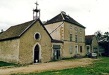
 Saint-Maurice Church |
||
Greux is a French municipality located 270 meters above sea level in the Vosges department in the Grand Est region (until 2015 Lorraine ). It was one of the 21 municipalities of the canton of Coussey and was defeated by the reorganization of the French cantons in 2015 to the canton of Neufchâteau in the arrondissement of the same name .
Geography, infrastructure
Greux is passed by Route nationale 66 and the former RN 64 . The latter was downgraded to the Départementsstraße D166.
The Vair flows into the Meuse between Greux and Moncel-sur-Vair .
Other neighboring communities are Vouthon-Haut in the north-west, Goussaincourt in the north, Brixey-aux-Chanoines in the north-east, Maxey-sur-Meuse in the east, Domrémy-la-Pucelle in the south and Les Roises in the west.
Population development
| year | 1962 | 1968 | 1975 | 1982 | 1990 | 1999 | 2008 | 2014 |
|---|---|---|---|---|---|---|---|---|
| Residents | 171 | 157 | 139 | 164 | 141 | 144 | 165 | 166 |
Attractions
- Bermont Chapel, Monument historique
- Saint-Maurice church from the 12th century
Web links
Commons : Greux - collection of images, videos and audio files

