Godoncourt
| Godoncourt | ||
|---|---|---|
|
|
||
| region | Grand Est | |
| Department | Vosges | |
| Arrondissement | Neufchâteau | |
| Canton | Darney | |
| Community association | Vosges Côté Sud Ouest | |
| Coordinates | 48 ° 0 ' N , 5 ° 55' E | |
| height | 234-362 m | |
| surface | 11.38 km 2 | |
| Residents | 124 (January 1, 2017) | |
| Population density | 11 inhabitants / km 2 | |
| Post Code | 88410 | |
| INSEE code | 88208 | |
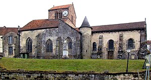
 Saint-Remy church |
||
Godoncourt is a French commune in the Vosges department in the Grand Est region with 124 inhabitants (as of January 1, 2017). It belongs to the Neufchâteau district and the Darney canton .
geography
The municipality is located on the upper Saône in the extreme southwest of the former Lorraine region. Neighboring communities of Godoncourt are Monthureux-sur-Saône in the northeast, Regnévelle in the east, Bousseraucourt in the south, Fignévelle and Les Thons in the southwest and Saint-Julien in the northwest.
Web links
Commons : Godoncourt - collection of images, videos and audio files
