
Removille
| Removille | ||
|---|---|---|

|
|
|
| region | Grand Est | |
| Department | Vosges | |
| Arrondissement | Neufchâteau | |
| Canton | Mirecourt | |
| Community association | Ouest Vosgien | |
| Coordinates | 48 ° 22 ′ N , 5 ° 50 ′ E | |
| height | 297-458 m | |
| surface | 7.55 km 2 | |
| Residents | 214 (January 1, 2017) | |
| Population density | 28 inhabitants / km 2 | |
| Post Code | 88170 | |
| INSEE code | 88387 | |
 Mairie Removille |
||

Removille is a French commune with 214 inhabitants (January 1, 2017) in the Vosges department in the Grand Est region . It belongs to the Arrondissement Neufchâteau and the municipality association Ouest Vosgien .
geography
The municipality of Removille is located at about 310 m above sea level in the southwest of Lorraine, about 14 kilometers east of Neufchâteau and about 35 kilometers south of Toul . The village extends in the wooded transition area between the Bassigny as part of the Langres plateau and the Xaintois .
The area of the 7.55 km² municipal area comprises a section of the hilly landscape in the area of the Maas tributary Vair , whose winding course limits the municipality to the west. In the municipality's area, the Vraine joins the Vair from the southeast. The valleys are flanked by partially wooded hills. The municipality includes the forest areas Bois Michaud in the north and Les Fourches in the northwest. Forests make up almost 40 percent of the municipal area. A slightly larger part of the community area is available for agriculture. At 458 m, the highest point is reached on a wooded mountain spur in the north of the municipality.
Neighboring communities of Removille are Aouze in the northeast, Rainville in the east, Balléville in the southeast, Vouxey in the southwest, Houéville in the west (point of contact) and Attignéville in the northwest.
history
In 1621, Removille appeared for the first time in documents as the seat of a local knight dynasty and manor. A castle near Removille from the 12th century, which can be assigned to the knight family, was destroyed by the Swedes in 1636. In the period before the French Revolution, Removille belonged to the Bailiwick of Neufchâteau and the Provostei Châtenois. The church was part of the Châtenois deanery in the diocese of Toul . The lords of Removille - later the lords of Bassompierre, whose three red rafters on a silver background still adorn the municipal coat of arms - held the lower , middle and high jurisdiction . From 1790 to 1792 Removille was temporarily the seat of a canton.
Population development
| year | 1962 | 1968 | 1975 | 1982 | 1990 | 1999 | 2006 | 2017 | |
| Residents | 236 | 218 | 198 | 228 | 213 | 206 | 202 | 214 | |
| Sources: Cassini and INSEE | |||||||||
Attractions
- Church of Our Lady ( Église Notre-Dame ) from the 16th century on a mountain spur above the village with a listed portal
- Chapel of St. Nicholas ( Chapelle Saint-Nicolas ) on the main street of the village, built at the end of the 16th century, Monument historique
- Ruins of the Notre-Dame-du-Bon-Repos chapel in a forest northeast of the village, today only accessible from the neighboring community of Aouze
- Wegkreuz la Madone on a plateau above the church
- Wayside cross in the northwest of the village, monument historique

Notre-Dame church
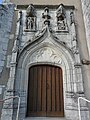
Portal of the Church of Notre-Dame

Wayside cross on rue des Halles

Wash house ( Lavoir ) in Removille


Economy and Infrastructure
Agriculture still plays an important role in Removille today. There are eight farms in the community (dairy farming, cattle, sheep and goat breeding). Some residents commute to the industrial areas around Châtenois and Neufchâteau or to the health resorts of Contrexéville and Vittel to the south .
The D 3 main road from Coussey to Gironcourt-sur-Vraine runs through Removille . In the southeast the A31 autoroute ( Toul - Dijon ) touches the municipality; the next motorway junction is six kilometers south of Removille. There are road links to the surrounding communities of Aouze , Houéville and Vouxey .
Personalities
One of the lords of Removille was Étienne-François de Choiseul , one of the leading French statesmen during the Ancien Régime.
supporting documents
- ^ Removille on vosges-archives.com. (pdf) (No longer available online.) Archived from the original on March 4, 2016 ; Retrieved on August 19, 2014 (French). Info: The archive link was inserted automatically and has not yet been checked. Please check the original and archive link according to the instructions and then remove this notice.
- ↑ Description of the coat of arms on genealogie-lorraine.fr (French)
- ↑ Removille on cassini.ehess.fr
- ↑ Removille on insee.fr
- ^ Notre-Dame Church in the Base Mérimée of the Ministry of Culture. Retrieved August 19, 2014 (French).
- ↑ Saint-Nicolas Chapel in the Base Mérimée of the Ministry of Culture. Retrieved August 19, 2014 (French).
- ^ Wayside cross in the Base Mérimée of the Ministry of Culture. Retrieved August 19, 2014 (French).
- ↑ Farms on annuaire-mairie.fr (French)