Bonvillet
| Bonvillet | ||
|---|---|---|
|
|
||
| region | Grand Est | |
| Department | Vosges | |
| Arrondissement | Neufchâteau | |
| Canton | Darney | |
| Community association | Vosges Côté Sud Ouest | |
| Coordinates | 48 ° 6 ' N , 6 ° 3' E | |
| height | 264–342 m | |
| surface | 10.09 km 2 | |
| Residents | 300 (January 1, 2017) | |
| Population density | 30 inhabitants / km 2 | |
| Post Code | 88260 | |
| INSEE code | 88065 | |
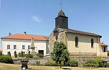
 Mayor and school building in Bonvillet |
||
Bonvillet is a French commune in the department of Vosges of the region Grand Est (2015 Lorraine ). It belongs to the Arrondissement Arrondissement Neufchâteau and the Canton of Darney .
geography
The municipality with 300 inhabitants (January 1, 2017) is located on the upper Saône , around 18 kilometers south-east of Vittel .
Population development
| year | 1793 | 1896 | 1954 | 1982 | 1990 | 1999 | 2006 | 2017 |
| Residents | 388 | 411 | 295 | 377 | 430 | 372 | 343 | 300 |
Attractions
- Saint-Epvre Church
Web links
Commons : Bonvillet - collection of images, videos and audio files

