
Jubainville
| Jubainville | ||
|---|---|---|

|
|
|
| region | Grand Est | |
| Department | Vosges | |
| Arrondissement | Neufchâteau | |
| Canton | Neufchâteau | |
| Community association | Ouest Vosgien | |
| Coordinates | 48 ° 28 ′ N , 5 ° 45 ′ E | |
| height | 280-421 m | |
| surface | 4.33 km 2 | |
| Residents | 91 (January 1, 2017) | |
| Population density | 21 inhabitants / km 2 | |
| Post Code | 88630 | |
| INSEE code | 88255 | |
 Mairie Jubainville |
||

Jubainville (1801 still with the spelling Subainville ) is a French commune with 91 inhabitants (January 1, 2017) in the Vosges department in the Grand Est region ( Lorraine until 2015 ). It is part of the Neufchâteau arrondissement and the Ouest Vosgien community association founded in 2017 .
geography

The municipality is located about 15 kilometers north of Neufchâteau and about 32 kilometers southwest of Toul in southwest Lorraine. By the municipality Jubainville flowing in south-north direction Ruisseau des Chaudrons which is located at the northern tip of the municipality of the Ruisseau de l'Orge for Ruisseau de Ruppes united, then the few kilometers downstream in the Meuse flows. The highest point in the municipality is an unnamed altitude (421 meters above sea level) in a wooded area ( Bois Brûlé ) on the border with the municipality of Maxey-sur-Meuse .
Neighboring municipalities of Jubainville are Sauvigny ( Département Meuse ) in the north, Clérey-la-Côte in the northeast, Ruppes in the east, Soulosse-sous-Saint-Élophe in the south, Maxey-sur-Meuse in the west and Brixey-aux-Chanoines (Département Meuse ) in the north-west.
Population development
| year | 1962 | 1968 | 1975 | 1982 | 1990 | 1999 | 2006 | 2016 |
| Residents | 95 | 71 | 78 | 77 | 89 | 68 | 88 | 93 |
| Sources: Cassini and INSEE | ||||||||
Attractions
- Saint-Euchaire church
- Fallen memorial
- Fountain
- crossroads

Saint-Euchaire church
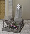
Fallen memorial


Economy and Infrastructure
Agriculture continues to dominate in Jubainville, in particular cattle farming and grain cultivation.
Jubainville is located on the D 19 main road from Greux to Autreville . There is a connection to the A 31 autoroute 15 kilometers to the northeast .
Transport links
The D19 road from Greux to Autreville runs through Jubainville .
supporting documents
- ↑ toponym on cassini.ehess.fr (French)
- ↑ Jubainville on cassini.ehess.fr (French)
- ↑ Jubainville on INSEE
- ↑ Farms on annuaire-mairie.fr (French)