La Vacheresse-et-la-Rouillie
| La Vacheresse-et-la-Rouillie | ||
|---|---|---|
|
|
||
| region | Grand Est | |
| Department | Vosges | |
| Arrondissement | Neufchâteau | |
| Canton | Vittel | |
| Community association | Terre d'Eau | |
| Coordinates | 48 ° 9 ' N , 5 ° 47' E | |
| height | 333-443 m | |
| surface | 9.36 km 2 | |
| Residents | 125 (January 1, 2017) | |
| Population density | 13 inhabitants / km 2 | |
| Post Code | 88140 | |
| INSEE code | 88485 | |
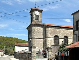
 Town hall ( mairie ) with wash house ( lavoir ) in La Vacheresse |
||
La Vacheresse-et-la-Rouillie is a French commune with 125 inhabitants (January 1, 2017) in the Vosges department in the Grand Est region (until 2015 Lorraine ). It is part of the Neufchâteau arrondissement and the Terre d'Eau community association founded in 2017 .
geography
The municipality is located about 15 kilometers southwest of Vittel in the extreme southwest of Lorraine between the landscapes of Bassigny in the southwest and Xaintois in the northeast. From the south-east, the foothills of the Monts Faucilles extend over to the municipal area (in the Le Trainechard forest area, the highest point is reached at 443 m above sea level). The Anger flows through the municipality , a tributary of the Mouzon , which belongs to the catchment area of the Meuse . Almost half of the 9.36 km² community area is covered with forest, which extends to the north and south-west.
Neighboring municipalities of La Vacheresse-et-la-Rouillie are Saint-Ouen-lès-Parey in the north-west and north, Crainvilliers in the east, Martigny-les-Bains in the south and Sauville in the south-west.
history
The names of the villages La Vacheresse and La Roulie have been attested since 1280. They were part of the Bailiwick of Bassigny and the provost of Bourmont. As in the neighboring village of Crainvilliers, the Torneille, Chatelet and Coublans families ruled with the most extensive holdings. Ecclesiastically, La Vacheresse initially belonged to the parish of Saint-Ouen-lès-Parey, which was under the Remiremont chapter ; the village of La Rouillie ecclesiastically annexed the parish of Crainvilliers under the rule of the abbot of Flabémont .
population
The community is located in the structurally weak south-west of the Vosges department, which recorded above-average population losses. The peak was reached in 1836, when there were still 614 residents in La Vacheresse-et-la-Rouillie.
| year | 1962 | 1968 | 1975 | 1982 | 1990 | 1999 | 2006 | 2017 | |
| Residents | 178 | 141 | 145 | 149 | 147 | 125 | 121 | 125 | |
| Sources: Cassini and INSEE | |||||||||
Attractions
Economy and Infrastructure
There are five farms in the municipality (dairy farming, cattle, sheep and goat breeding).
La Vacheresse-et-la-Rouillie is located off the main national transport routes. There are road links to the neighboring municipalities of Sauville, Saint-Ouen-lès-Parey, Crainvilliers and Martigny-les-Bains. The train station in the small town of Martigny-les-Bains, seven kilometers away, is on the railway line from Nancy to Culmont - Chalindrey , which is operated by TER Lorraine . In Robécourt , twelve kilometers away, there is a connection to the A31 autoroute .
supporting documents
- ↑ History on vosges-archives.com ( Memento of the original from December 8, 2015 in the Internet Archive ) Info: The archive link was automatically inserted and not yet checked. Please check the original and archive link according to the instructions and then remove this notice. (PDF file, French)
- ↑ La Vacheresse-et-la-Rouillie on cassini.ehess.fr
- ↑ La Vacheresse-et-la-Rouillie on insee.fr
- ↑ Farms on annuaire-mairie.fr (French)


