Morizécourt
| Morizécourt | ||
|---|---|---|

|
|
|
| region | Grand Est | |
| Department | Vosges | |
| Arrondissement | Neufchâteau | |
| Canton | Darney | |
| Community association | Vosges Côté Sud Ouest | |
| Coordinates | 48 ° 4 ' N , 5 ° 52' E | |
| height | 279-422 m | |
| surface | 10.68 km 2 | |
| Residents | 107 (January 1, 2017) | |
| Population density | 10 inhabitants / km 2 | |
| Post Code | 88320 | |
| INSEE code | 88314 | |
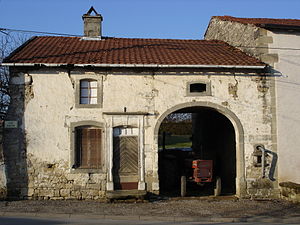
 typical Lorraine house in Morizécourt |
||
Morizécourt is a French commune with 107 inhabitants (as of January 1, 2017) in the Vosges department in the Grand Est region (until 2015 Lorraine ). Morizécourt is part of the Neufchâteau arrondissement and the Darney canton .
geography
Morizécourt is about 15 kilometers south of Contrexéville . The Ruisseau de la Chèvre , which has its source in Morizécourt, is a tributary of the upper Saône . Morizécourt is surrounded by the neighboring communities of Frain in the northeast, Tignécourt in the southeast, Serécourt in the south, Lamarche in the west and Martigny-les-Bains in the northwest.
Population development
| year | 1962 | 1968 | 1975 | 1982 | 1990 | 1999 | 2014 | |
| Residents | 177 | 169 | 160 | 150 | 141 | 133 | 114 | |
| Source: Cassini and INSEE | ||||||||
Attractions
- Saint-Maurice church with a Romanesque choir from the 12th century
- former priory
- Castle ( Château de Deuilly )
Web links
Commons : Morizécourt - collection of images, videos and audio files
