
Belrupt
| Belrupt | ||
|---|---|---|

|
|
|
| region | Grand Est | |
| Department | Vosges | |
| Arrondissement | Neufchâteau | |
| Canton | Darney | |
| Community association | Vosges Côté Sud Ouest | |
| Coordinates | 48 ° 5 ' N , 6 ° 6' E | |
| height | 278-358 m | |
| surface | 8.14 km 2 | |
| Residents | 102 (January 1, 2017) | |
| Population density | 13 inhabitants / km 2 | |
| Post Code | 88260 | |
| INSEE code | 88052 | |
 Mairie Belrupt |
||

Belrupt is a commune in the Vosges department in the Grand Est region of France . It belongs to the Arrondissement Neufchâteau and the municipality association Vosges Côté Sud Ouest .
geography

The community of Belrupt with 102 inhabitants (January 1, 2017) is located at an average altitude of around 330 m above sea level, 35 kilometers southwest of Épinal and 25 kilometers southeast of Vittel in the extreme south of Lorraine near the border with the Franche-Comté region . The 8.14 km² large municipal area is located on the Vôge plateau on the upper Saône , the source of which is in the neighboring municipality of Vioménil to the east . Other bodies of water in the municipality of Belrupt are the mountain streams Ruisseau de Brandômont, La Houdine and Ruisseau de l'Étang de Belrupt and the lakes Étang Chantrelle, Étang du Bourlier and Étangs des Receveurs . By far the largest part of the communal area belongs to the Forêt Domaniale de Darney , one of the largest contiguous mixed forest areas in Lorraine. Agricultural land can only be found around the core town, which is located on a cleared island .
Belrupt includes the hamlets and farms of Les Abatteux, Le Vieux Moulin and Ferme du Bon Jacques .
Belrupt's neighboring communities are Dombasle-devant-Darney and Jésonville in the north, Escles in the northeast, Vioménil in the east, Hennezel in the southeast, Darney in the southwest and Bonvillet in the northwest.
history
At the end of the 14th century, the name Belrupt appears for the first time in a document as one of the mansions of the later Counts of Hennezel . Even in the middle of the 16th century, the Lords of Hennezel still owned goods in and around Belrupt. Other lands around Belrupt belonged to the Duchess of Lorraine . From 1549 Charles du Tysal , a brother of Count von Hennezel, resided in the remains of a feudal castle, which at that time formed the center of the village. Apart from the tower foundations, nothing remains of this castle today. The lord of the castle founded a glassworks in Belrupt, of which there were many in the dense forests around Darney. Today a glass museum in the nearby Hennezel district of Clairey reminds of the glassworks and charcoal burners. Charles de Thysac's son, Rémy de Thysac , died in 1616. His son, Eric Thysac , was a cavalry colonel and a follower of Duke Charles IV. The silver lion on a blue background - today's municipal coat of arms - dates from this period. The last representative from the manor house before the French Revolution carried the title Baron von Belrupt, Bonvillet and Valfroicourt and Count von Monthureux . In 1705, the baron's debts were so great that the creditors sold all lands, including the high jurisdiction. The beneficiaries included Francois du Houx from Viomenil and the gentlemen from Fauconcourt . In 1751 Belrupt belonged to the Darney Bailiwick . A castle was built on the foundations of the old castle in the 18th century, whereby the old tower was preserved and still served as a prison at times.
The single-track railway line, which runs through the municipality of Belrupt and crosses the Saône here, was built in 1886 for strategic military reasons. Until it was closed in 1964, it ran from Jussey in the Haute-Saône department via Harol to Darnieulles / Uxegney .
Population development
| year | 1962 | 1968 | 1975 | 1982 | 1990 | 1999 | 2007 | 2017 | |
| Residents | 146 | 136 | 113 | 103 | 116 | 111 | 107 | 102 | |
| Sources: Cassini and INSEE | |||||||||
Attractions
- The small church of St. Laurentius ( Église Saint-Laurent ) has a slate-roofed tower typical of the Vôge . The current shape of the church comes from a reconstruction from 1763.
- Water tower on the southern edge of the village
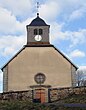
St. Laurentius Church

Water tower


Economy and Infrastructure
There are three farms in the municipality (dairy farming, horse breeding). Some residents commute to the nearby small town of Darney . A sandstone quarry not far from the Saône has long since been abandoned, and the old water mill has also been out of service for decades.
Belrupt is located away from the nationally important traffic routes. The D 460 road runs north of the municipality from Épinal via Girancourt to Darney . Other road connections lead from Belrupt to Jésonville and Attigny . The next train station is in the spa town of Vittel .
supporting documents
- ↑ Belrupt. (PDF) (No longer available online.) In: www.vosges-archives.com. Formerly in the original ; accessed on October 17, 2010 (French, no longer available since 2012). ( Page no longer available , search in web archives ) Info: The link was automatically marked as defective. Please check the link according to the instructions and then remove this notice.
- ^ Jussey-Uxegney railway line. (No longer available online.) In: www.transports-vosges.pagesperso-orange.fr. Archived from the original on April 12, 2013 ; accessed on January 31, 2018 (French).
- ↑ Belrupt on cassini.ehess.fr
- ↑ Belrupt on insee.fr
- ↑ Farms on annuaire-mairie.fr (French)