Belmont-lès-Darney
| Belmont-lès-Darney | ||
|---|---|---|
|
|
||
| region | Grand Est | |
| Department | Vosges | |
| Arrondissement | Neufchâteau | |
| Canton | Darney | |
| Community association | Vosges Côté Sud Ouest | |
| Coordinates | 48 ° 5 ' N , 6 ° 1' E | |
| height | 267-360 m | |
| surface | 3.99 km 2 | |
| Residents | 112 (January 1, 2017) | |
| Population density | 28 inhabitants / km 2 | |
| Post Code | 88260 | |
| INSEE code | 88049 | |
 Church of St. Faustus and St. Jovinus |
||
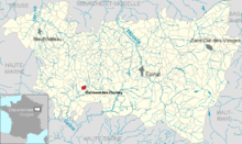
Belmont-lès-Darney is a French commune with 112 inhabitants (January 1, 2017) in the Vosges department in the Grand Est region ( Lorraine until 2015 ). It belongs to the Arrondissement Neufchâteau and the municipality association Vosges Côté Sud Ouest .
geography
The municipality of Belmont-lès-Darney is located three kilometers west of Darney , 17 kilometers south of Vittel and 42 kilometers southwest of Épinal .
The municipality covers a section of the hill country of Monts Faucilles . The Ruisseau de Lichecourt (called below Belmonts Ruisseau de Belmont ) flows through the municipality and flows into the upper Saône in Attigny . About 10% of the four square kilometers large municipal area are forested ( Bois le Comte in the northeast).
Neighboring communities of Belmont-lès-Darney are Relanges in the north, Darney in the east, Attigny in the south and Nonville in the west.
history
The place appeared for the first time in 1321 in a document as Beaumont . In the 14th century Belmont was part of the Monthureux rule , who later sold the village to the Bulgnéville lords .
From 1751 until the French Revolution, Belmont was part of the Darney Bailiwick. The residents were parish in the parish Nonville, which belonged to the Relanges priory. Before the church was built, there was a small chapel in Belmont. In 1961 the parish name was changed from Belmont to Belmont-lès-Darney to better distinguish it from other parishes called Belmont .
Population development
| year | 1962 | 1968 | 1975 | 1982 | 1990 | 1999 | 2007 | 2017 | |
| Residents | 94 | 109 | 101 | 98 | 117 | 113 | 121 | 112 | |
| Sources: Cassini and INSEE | |||||||||
Attractions
- Saints-Faust-et-Jovin Church, built 1850–1856
Economy and Infrastructure
There are three dairy farms in the municipality.
Belmont is on the D56 trunk road from Bleurville to Darney . In the small town of Darney, three kilometers away, the roads from Épinal to Bourbonne-les-Bains and from Vittel to Luxeuil-les-Bains cross .
supporting documents
- ↑ Belmont-lès-Darney on vosges-archives.com ( Memento of the original from January 16, 2016 in the Internet Archive ) Info: The archive link was inserted automatically and has not yet been checked. Please check the original and archive link according to the instructions and then remove this notice. (PDF file, French; 59 kB)
- ↑ Entry on genealogie-bisval.net ( page no longer available , search in web archives ) Info: The link was automatically marked as defective. Please check the link according to the instructions and then remove this notice. (French)
- ↑ toponym on cassini.ehess.fr
- ↑ Belmont-lès-Darney on cassini.ehess.fr
- ↑ Belmont-lès-Darney on insee.fr
- ↑ Farms on annuaire-mairie.fr (French)

