
Vouxey
| Vouxey | ||
|---|---|---|

|
|
|
| region | Grand Est | |
| Department | Vosges | |
| Arrondissement | Neufchâteau | |
| Canton | Mirecourt | |
| Community association | Ouest Vosgien | |
| Coordinates | 48 ° 21 ′ N , 5 ° 50 ′ E | |
| height | 297-453 m | |
| surface | 23.28 km 2 | |
| Residents | 138 (January 1, 2017) | |
| Population density | 6 inhabitants / km 2 | |
| Post Code | 88170 | |
| INSEE code | 88523 | |
 Mairie Vouxey |
||

Vouxey is a French commune with 138 inhabitants (as of January 1, 2017) in the Vosges department in the Grand Est region (until 2015 Lorraine ). It belongs to the Arrondissement Neufchâteau and the canton Mirecourt (until 2015: canton Châtenois ).
geography
Vouxey is about 45 kilometers south-southwest of Nancy . The eastern boundary of the municipality is formed by the river Vair , into which the Vraine flows here. Vouxey is surrounded by the neighboring communities of Barville and Houéville in the north, Removille in the east and northeast, Balléville in the southeast, Dolaincourt and Châtenois in the south, Rouvres-la-Chétive in the southwest and Rollainville in the northwest.
Population development
| year | 1962 | 1968 | 1975 | 1982 | 1990 | 1999 | 2006 | 2012 |
| Residents | 153 | 138 | 136 | 130 | 134 | 152 | 167 | 163 |
| Source: Cassini and INSEE | ||||||||
Attractions
- Saint Martin Church
- Two monumental crosses from the 16th century
- two lavoirs
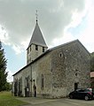
St. Martin Church
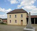
School and war memorial

Lavoir on Rue du Vendrillon

Lavoir on Rue du Bussing


