Dombrot-le-Sec
| Dombrot-le-Sec | ||
|---|---|---|
|
|
||
| region | Grand Est | |
| Department | Vosges | |
| Arrondissement | Neufchâteau | |
| Canton | Vittel | |
| Community association | Vosges Côté Sud Ouest | |
| Coordinates | 48 ° 9 ' N , 5 ° 55' E | |
| height | 357-485 m | |
| surface | 18.89 km 2 | |
| Residents | 376 (January 1, 2017) | |
| Population density | 20 inhabitants / km 2 | |
| Post Code | 88140 | |
| INSEE code | 88140 | |
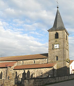
 Saint-Brice fortified church |
||
Dombrot-le-Sec is a French commune in the department of Vosges of the region Grand Est (2015 Lorraine ). It is part of the Neufchâteau arrondissement and the Vosges Côté Sud Ouest community association founded in 2017 .
geography
The municipality of Dombrot-le-Sec, with 376 inhabitants (January 1, 2017), is located a few kilometers south of the health resorts of Vittel and Contrexéville in the southwest of the historic Lorraine region .
The almost 19 km² large municipal area of Dombrot-le-Sec extends in the area of the Monts Faucilles on the watershed of the catchment areas of the Meuse and Saône . The Vair , a 65 km long tributary of the upper Meuse, has its source in the municipality . Around 400 hectares of the south-western parish are forested.
About 14 kilometers north of Dombrot, also on the river Vair, is a community of the same name. For better differentiation, the villages were renamed Dombrot-sur-Vair and Dombrot-le-Sec ( sec = dry).
Neighboring municipalities of Dombrot-le-Sec are Contrexéville in the north, Lignéville in the northeast, Viviers-le-Gras in the southeast, Gignéville , Marey and Serocourt in the south, Martigny-les-Bains in the southwest and Crainvilliers in the west.
history
In 1711 Dombrot-le-Sec belonged to the domain of Claude-Rene de Lignéville , Countess of Monchat. From 1751 until the French Revolution , Dombrot-le-Sec was part of the Bailiwick of Darney . The residents belonged to the parish of Vittel.
Population development
| year | 1962 | 1968 | 1975 | 1982 | 1990 | 1999 | 2007 | 2017 | |
| Residents | 342 | 369 | 379 | 406 | 409 | 358 | 354 | 376 | |
| Sources: Cassini and INSEE | |||||||||
Attractions
- Fortified church Saint-Brice ( St. Brictius ) from the 13th century, when historique monument classified
- Castle ( Château de Dombrot )
Economy and Infrastructure
There are 18 farms in the community (grain cultivation, dairy farming, breeding of horses, cattle, sheep and goats).
Dombrot-le-Sec is a regional transport hub. Here the branches towards Langres leading D 429 from the D 164 ( Neufchâteau - Bains-les-Bains ) from.
supporting documents
- ↑ Dombrot-le-Sec on vosges-archives.com ( Memento of the original dated December 8, 2015 in the Internet Archive ) Info: The archive link was inserted automatically and has not yet been checked. Please check the original and archive link according to the instructions and then remove this notice. (PDF file, French; 69 kB)
- ↑ Dombrot-le-Sec on cassini.ehess.fr
- ↑ Dombrot-le-Sec on insee.fr
- ↑ Entry on culture.gouv.fr (French)
- ↑ Farms on annuaire-mairie.fr (French)


