
Hagnéville-et-Roncourt
| Hagnéville-et-Roncourt | ||
|---|---|---|
|
||
| region | Grand Est | |
| Department | Vosges | |
| Arrondissement | Neufchâteau | |
| Canton | Vittel | |
| Community association | Terre d'Eau | |
| Coordinates | 48 ° 15 ' N , 5 ° 48' E | |
| height | 340-487 m | |
| surface | 5.55 km 2 | |
| Residents | 87 (January 1, 2017) | |
| Population density | 16 inhabitants / km 2 | |
| Post Code | 88300 | |
| INSEE code | 88227 | |
 Mairie Hagnéville-et-Roncourt |
||

Hagnéville-et-Roncourt is a French commune with 87 inhabitants (as of January 1, 2017) in the Vosges department in the Grand Est region (until 2015: Lorraine ). The municipality is part of the Neufchâteau arrondissement and the Terre d'Eau municipal association founded in 2017 .
geography
The municipality of Hagnéville-et-Roncourt is located on the northeastern edge of the Bassigny countryside between the towns of Neufchâteau and Vittel . The two villages of Hagnéville and Roncourt are four kilometers apart. Hagnéville-et-Roncourt is surrounded by the neighboring communities of Aulnois in the north, Ollainville in the northeast, Sandaucourt in the east, Bulgnéville in the southeast, Morville in the south, Malaincourt in the southwest and Beaufremont in the west. The forest Bois d'Hagnéville in the middle of the municipality separates the two villages that give it their name and also the catchment areas of the rivers Anger in the west and Vair in the east. In a wooded area to the west of the municipality ( Bois des Roches ) is the highest point of Hagnéville-et-Roncourt at 487 m above sea level.
history
The municipality was created on January 1, 1978 through the merger of the two previously independent municipalities Roncourt and Hagnéville.
Population development
| year | 1982 | 1990 | 1999 | 2008 | 2016 |
| Residents | 91 | 104 | 89 | 82 | 88 |
| Sources: Cassini and INSEE | |||||
In 1975, before the merger with Hagnéville, Roncourt only had 18 residents.
Attractions
- Sainte-Gontrude church in Hagnéville
- Church of the Assumption in Roncourt
- Fountain in Roncourt
- Monumental cross in Hagnéville from the 16th century, Monument historique
- Churches in Hagnéville-et-Roncourt

Sainte-Gontrude Church
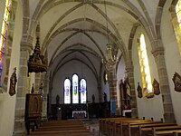
Interior view of Sainte-Gontrude
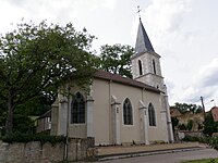
Church of the Assumption
.JPG)
.JPG)

Economy and Infrastructure
There are five farms in Hagnéville-et-Roncourt (grain and dairy farming).
The trunk road from Neufchâteau to Vittel (D 164) leads through Hagnéville-et-Roncourt, which meets the A31 autoroute in Bulgnéville , five kilometers south-east of Hagnéville-et-Roncourt . The station in Contrexéville , 14 kilometers away , is on the railway line from Nancy to Culmont - Chalindrey , which is operated by TER Lorraine .
supporting documents
- ↑ Hagnéville-et-Roncourt on cassini.ehess.fr (French)
- ↑ Hagnéville-et-Roncourt on INSEE
- ↑ Statistics Roncourt on cassini.ehess.fr
- ^ Entry in the Base Mérimée of the Ministry of Culture. Retrieved September 12, 2016 (French).
- ↑ Company on annuaire-mairie.fr.fr (French)