Rambervillers
| Rambervillers | ||
|---|---|---|

|
|
|
| region | Grand Est | |
| Department | Vosges | |
| Arrondissement | Epinal | |
| Canton | Saint-Dié-des-Vosges-1 | |
| Community association | Region of Rambervillers | |
| Coordinates | 48 ° 21 ' N , 6 ° 38' E | |
| height | 272-348 m | |
| surface | 20.64 km 2 | |
| Residents | 5,170 (January 1, 2017) | |
| Population density | 250 inhabitants / km 2 | |
| Post Code | 88700 | |
| INSEE code | 88367 | |
| Website | www.ville-rambervillers.fr | |
 Location of the municipality of Rambervillers in the Vosges department |
||
Rambervillers (1793 still with the spelling Rembervillers ) is a French commune with 5170 inhabitants (January 1, 2017) in the Vosges department in the Grand Est region . It belongs to the Épinal arrondissement and is the seat of the Région de Rambervillers municipal association founded in 2006 .
geography
The small town of Rambervillers is located on the Mortagne River on the edge of the Vosges , about 23 kilometers northeast of Épinal and 35 kilometers west of Saint-Dié .
The municipality of Rambervillers comprises a section of the Mortagnetales, which runs in a south-east-north-west direction and which widens here through several tributaries. Coming from the south the Padozel and the Arentèle , coming from the southeast and east the Gaindrupt and the Monseigneur flow to Mortagne. To the east of Rambervillers, the terrain rises to heights of over 500 meters above sea level. They are overcome by the Col de la Chipotte and Col du Haut du Bois passes in the direction of the Meurthetal . To the west of Rambervillers the relief becomes calmer and flatter. Forests spread out here, of which the Forêt de Rambervillers , together with the Forêt de Padoux, Le Grand Bois and Forêt Saint Pierre, form a closed forest area of over 50 km².
The center developed on the right bank of the Mortagne, spread over one of the two existing bridges in the inner city area to the left side of the river. When it rains heavily, Rambervillers is often threatened by flooding. In September 2006, around 50 houses were partially flooded.
Rambervillers includes the Métendal district in the northeast of the municipality and a few scattered farms. To the southeast, commercial areas adjoin the town center. These are the industrial areas (ZI = Zone Industrielle) ZI la Grande Fin Nord, ZI la Grande Fin Sud and ZI le Haut Fourneau 1 and 2 .
Neighboring municipalities of Rambervillers are Doncières in the north, Anglemont in the north-east, Brû in the east, Jeanménil in the south-east, Saint-Gorgon in the south, Vomécourt in the south-west, Romont in the west and Roville-aux-Chênes in the north-west.
history
The name of today's small town Rambervillers goes back to an abbot of Senones or a lord of Mortagne named Rembert , the exact sources are unclear. In 1793 the community was still called Rembervillers . In the 12th century, the bishop of Metz Stephan von Bar had the place, which was surrounded by moats and wooden palisades, fortified with walls and towers. Rambervillers was the southernmost possession of the Metz bishops.
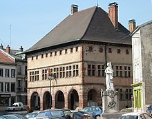
During the Huguenot Wars in the sixteenth century, the city was destroyed but quickly recovered. Already in 1591 the citizens built the town hall of Rambervillers. In 1718 Rambervillers came to the Duchy of Lorraine , which after the death of Stanislaus I. Leszczyński in 1766 fell to France according to the treaty . In the Franco-Prussian War on October 9, 1870, 200 national guards and 2,000 Germans faced each other. In 1896, the city received the Legion of Honor , the highest-ranking French award, for the heroic barricade fight .
In 1871 Rambervillers got a railway connection when the railway line to Charmes on the Moselle was opened. Passenger traffic was stopped on this route in 1935, freight traffic ended in 1962. From 1911 the railway line from Mont-sur-Meurthe (with connections to Nancy and Lunéville ) via Rambervillers to Bruyères was continuously passable. In 1980 passenger traffic on this route was also discontinued due to a lack of profitability;
coat of arms
Blazon : "On a silver background a red Lorraine cross, on it the sign of the Legion of Honor, accompanied by two crescent moons and the insignia IR in blue."
The coat of arms with the Lorraine cross was created in the time of Duke Leopold at the end of the 17th / beginning of the 18th century. The crescents recall the victories of his father Charles V in the Turkish wars . The initials IR stand for iuridiction de Rambervillers , the local jurisdiction. In 1896 the city was awarded the Legion of Honor , and since 1902 it has had the emblem in its coat of arms. Besides the coat of arms of Rambervillers, there are only very few left today (like the coat of arms of Roanne ) with the Legion of Honor in the middle of the shield. Cities like Dijon no longer have it today, while others like Belfort have found it in the base of the shield.
population
| year | 1962 | 1968 | 1975 | 1982 | 1990 | 1999 | 2007 | 2017 | |
|---|---|---|---|---|---|---|---|---|---|
| Residents | 7042 | 7229 | 7113 | 6595 | 5919 | 5999 | 5669 | 5170 | |
| Sources: Cassini and INSEE | |||||||||
With 5170 inhabitants (January 1, 2017), Rambervillers is still one of the ten most populous municipalities in the department of Vosges, despite the population decline since the 1970s. The reason for the emigration was the decline of traditional industries, especially the textile industry, metallurgy, wood processing and the paper industry from the mid-1970s. The trend was countered with the establishment of new industrial parks and the promotion of tourism projects, the process is not yet complete.
Attractions
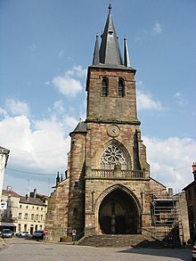
- Sainte-Libaire church from the 16th century, monument historique
- Hôtel de ville (town hall) from the 16th century, Monument historique
- In the Musée de la Terre - Museum of the Earth (s) - in Rue de la Faïencerie 1, the long tradition of Rambervillers as a production site for ceramics, tiles and faience is remembered.
Economy and Infrastructure
Rambervillers is a regional center that takes on the functions of medical care, education, administration and, last but not least, local transport for many surrounding communities. Numerous employees work in these areas. In the tourism sector, Rambervillers is represented with a hotel, guest houses and a campsite. Rambervillers is also an industrial location.
After the break-up of traditional industries in Rambervillers, medium-sized companies with a broader range of products have settled in new industrial areas.
The largest employer with around 350 employees is the French branch of the Austrian company Fritz Egger GmbH & Co. OG , based in St. Johann in Tirol , which produces chipboard in Rambervillers.
In Rambervillers, the Manufacture des Grandes Orgues, according to the company, is the oldest organ building company in the world. It is said to have existed since 1750. Another source dates the beginning of the family dynasty to 1853.
education
Rambervillers is home to two kindergartens, two public elementary schools and a secondary school ( collège ).
Transport links
Eight department streets meet in a star shape in Rambervillers . The main connections are the roads to Épinal and Saint-Dié-des-Vosges . The nearest train station is in Baccarat, 15 kilometers away, on the Nancy - Lunéville -Saint-Dié line following the Meurthetal , operated by the TER Lorraine company.
Town twinning
Partnerships have existed since 1978 with the Palatinate local community Kottweiler-Schwanden and since 1990 with the Walloon community Ellezelles .
Personalities
- Nicolaus Serarius (1555–1609), Lorraine Jesuit, exegete and historian
- Charles Louis Gratia (1815-1911), French painter
- Jean-Pierre Vuillemin (* 1967), Roman Catholic clergyman, auxiliary bishop in Metz
Others
On February 22, 2003, at 9:41 p.m., a 5.4 magnitude earthquake occurred, the epicenter of which was in the Rambervillers area.
See also
→ Rambervillers Jewish community
supporting documents
- ↑ toponym on cassini.ehess.fr
- ↑ Again severe storms on ntv.de (last paragraph). Retrieved December 25, 2010 .
- ↑ Description on transports-vosges.pagesperso-orange.fr. Retrieved December 26, 2010 (French).
- ↑ Description on transports-vosges.pagesperso-orange.fr. Retrieved December 26, 2010 (French).
- ↑ Description of the coat of arms on genealogie-lorraine.fr. Retrieved December 26, 2010 (French).
- ↑ Rambervillers on cassini.ehess.fr
- ↑ Rambervillers on insee.fr
- ↑ Mayor's greeting to ville-rambervillers.fr. Retrieved December 25, 2010 (French).
- ↑ data on cassini.ehess.fr. Retrieved December 25, 2010 (French).
- ↑ Entry on culture.gouv.fr. Retrieved December 26, 2010 (French).
- ↑ Entry on culture.gouv.fr. Retrieved December 26, 2010 (French).
- ↑ Manufacturing in Rambervillers on vosges.com. (No longer available online.) Formerly in the original ; Retrieved December 26, 2010 (French). ( Page no longer available , search in web archives ) Info: The link was automatically marked as defective. Please check the link according to the instructions and then remove this notice.
- ↑ Manufactory on ville-rambervillers.fr. Retrieved December 26, 2010 (French).
- ↑ La dynastie de Rambervillers on vosges.orgues.free.fr. Retrieved December 26, 2010 (French).
- ↑ ville-rambervillers.fr/vue d'ensemble. Retrieved December 26, 2010 (French).
Web links
- Community presentation (French)
- Posts on the story on ramberinfo.com (French)
- Rambervillers Earth Museum (French)
- Population statistics


